IMAGES TAKEN NEAR TO
Clarence Street, PONTYPOOL, NP4 6LQ
Introduction
This page details the photographs taken nearby to Clarence Street, NP4 6LQ by members of the Geograph project.
The Geograph project started in 2005 with the aim of publishing, organising and preserving representative images for every square kilometre of Great Britain, Ireland and the Isle of Man.

There are currently over 7.5m images from over14,400 individuals and you can help contribute to the project by visiting https://www.geograph.org.uk
Image Map
Images are licensed for reuse under creativecommons.org/licenses/by-sa/2.0
Notes
- Clicking on the map will re-center to the selected point.
- The higher the marker number, the further away the image location is from the centre of the postcode.
Image Listing (381 Images Found)
Images are licensed for reuse under creativecommons.org/licenses/by-sa/2.0
Image
Details
Distance
1
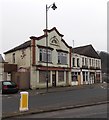
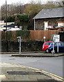
An unregenerated edge of Pontypool town centre
On my visit to Pontypool in February 2013, some results of the long-term regeneration of the town centre were in evidence, with several formerly shabby buildings restored to good condition.
The regeneration has not yet reached here, the corner of Clarence Street and Clarence Road.
Image: © Jaggery
Taken: 11 Feb 2013
0.01 miles
2
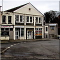
Fab Kabs, Pontypool
Fab Kabs taxi office is located in Henry Hughes House, Clarence Street.
Image: © Jaggery
Taken: 23 Sep 2011
0.01 miles
3
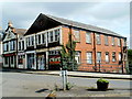
Henry Hughes House, Pontypool
Henry Hughes House is on the corner of Clarence Street and Clarence Road. In January 2015, there are several business names in view, including Capitol Hire, Clark Robert Durbin & Co and Fab Kabs. Above Fab Kabs is a ghost inscription NEWSPAPERS LIMITED. This building formerly housed the Pontypool Free Press newspaper.
The building was named for the paper's proprietor, printer and publisher, Henry Hughes. Deposited in 1978, various documents relating to Henry Hughes and the Pontypool Free Press are held in the Gwent Archive, now located in Ebbw Vale.
Image: © Jaggery
Taken: 27 Jan 2015
0.01 miles
4
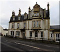
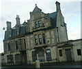
Ty Clarence, Pontypool
Offices and flats building viewed across Clarence Street in late January 2015. Ty Clarence was originally a tavern dating from the 1820s. It was the Clarence Hotel from c1870. There were major external alterations and extensions in the 1920s. The building was derelict http://www.geograph.org.uk/photo/258748 for about two decades from the mid 1980s.
Image: © Jaggery
Taken: 27 Jan 2015
0.02 miles
5
Griffithstown and Leisure Centre direction sign at the edge of Pontypool town centre
The sign shows that Leisure Centre is Canolfan Hamdden in Welsh.
Image: © Jaggery
Taken: 5 Dec 2019
0.02 miles
6
Fire-damaged roof, Snow White Laundries, Pontypool
Viewed from Clarence Road in late January 2015. The fire on December 3rd 2014 damaged a section of the roof of the single-storey building and caused extensive damage to the loading bay where many thousands of items of linen were stored. After the blaze, staff maintained normal service by working at the laundry's Cardiff factory. During the clean up after the fire, the head office and distribution centre continued to function in the undamaged part of the premises.
Image: © Jaggery
Taken: 27 Jan 2015
0.02 miles
7
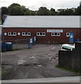
Snow White Laundries, Pontypool
The northern end of a 40 metres long building viewed from Clarence Road in July 2020.
Image: © Jaggery
Taken: 26 Jul 2020
0.02 miles
8
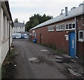
Access road to Snow White Laundries, Pontypool
From the north side of Clarence Road.
Image: © Jaggery
Taken: 26 Jul 2020
0.02 miles
9
Clarence Hotel, Clarence Corner, Pontypool
This photo is from 2004.
The building has been cleaned up since.
Image: © steve sims
Taken: 29 Aug 2004
0.02 miles
10
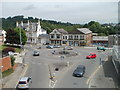
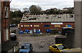
Clarence Street and Clarence Road, Pontypool
Viewed from a footbridge. Beyond the roundabout, Clarence Road is on the right. On the left, Clarence Street leads to the central shopping area of Pontypool.
Image: © Jaggery
Taken: 16 May 2011
0.02 miles