1
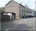
John Street, Pontypool
Houses on the west side of the street, viewed from Albion Road. The opposite side of the street is occupied by the perimeters of Lower Park Terrace houses.
Image: © Jaggery
Taken: 25 May 2011
0.03 miles
2
John Street cold calling control zone, Pontypool
Near the Albion Road junction, the sign on the left shows COLD CALLING CONTROL ZONE. This is one of many such zones in Torfaen. The Torfaen County Borough Council website states that in an effort to increase its effectiveness in combating doorstep crime, Torfaen Trading Standards have introduced Cold Calling Control Zones.
What is a Cold Calling Control Zone?
Doorstep crime includes all aspects of consumer detriment and crime arising from doorstep callers. This includes rogue workmen, high pressure sales people, bogus officials and distraction burglary, and it is well established that rogue traders and distraction burglary are often interrelated. In 2002 a national survey conducted by the Trading Standards Institute reported that 96% of people did not want doorstep cold callers and nobody actually welcomed them. 62% of those questioned reported receiving a cold caller in the previous three months.
It is not illegal to make an initial cold call, and a Cold Calling Control Zone has no legal status. However, new legislation has created offences for repeat callers and by working in partnership, such Zones give residents the confidence to say NO to individuals calling on them without a prearranged appointment, and gives the clear message that rogue traders and bogus callers are not welcome in the area.
Many bona fide businesses will make life easier for residents by simply popping a catalogue through the door. This avoids any feelings of confrontation on the doorstep and leaves the decision up to the individual as to whether to buy goods etc from the business concerned.
How does a Cold Calling Control Zone operate?
The Cold Calling Control Zone is very much a partnership initiative between Torfaen County Borough Council, Gwent Police and most importantly local residents themselves. The points of entry into the area will be designated by the placing of lamppost signs, and residents can reinforce the message by placing a sticker in a window close to the front door.
Image: © Jaggery
Taken: 27 Jan 2015
0.03 miles
3
Footbridge to Tesco Pontypool
Viewed from Upper Park Terrace. The footbridge crosses over the A4043 to a Tesco superstore. http://www.geograph.org.uk/photo/2437854
Image: © Jaggery
Taken: 16 May 2011
0.04 miles
4
Entrance to Tesco's Pontypool superstore
The address is Top Car Park, Lower Bridge Street, Pontypool.
Image: © Jaggery
Taken: 27 Jan 2015
0.05 miles
5
Tesco Pontypool
Viewed from the A4043 footbridge. The superstore is in central Pontypool (Lower Bridge Street).
Image: © Jaggery
Taken: 16 May 2011
0.05 miles
6
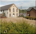
Pontypool : Upper Trosnant English Baptist Chapel viewed from the east
A view up Bridge Street. An inscription in a stone tablet on the front of the building shows BUILT 1820 RENOVATED 1885.
The building was Grade II listed in August 1997.
http://www.geograph.org.uk/photo/2460556 to a view from higher up Bridge Street.
Image: © Jaggery
Taken: 13 Jun 2011
0.05 miles
7
Pontypool : Upper Trosnant English Baptist Chapel viewed from the west
A view from the top of Bridge Street. An inscription in a stone tablet on the front of the building shows BUILT 1820 RENOVATED 1885.
The building was Grade II listed in August 1997.
http://www.geograph.org.uk/photo/2460546 to a view from lower down Bridge Street.
Image: © Jaggery
Taken: 13 Jun 2011
0.05 miles
8
Waste ground, Lower Bridge Street, Pontypool
A fenced-off area on the corner of Bridge Street and Lower Bridge Street was formerly the site of a British Red Cross building. Ahead is the Grade II listed Upper Trosnant English Baptist Chapel. http://www.geograph.org.uk/photo/2460556
On the right is the edge of Aneurin Bevan Court.
Image: © Jaggery
Taken: 13 Jun 2011
0.05 miles
9
Inwards goods area, Tesco, Pontypool
Viewed across Lower Bridge Street. This is where goods for the superstore are unloaded from lorries.
This is probably also where Tesco home delivery vans are loaded.
Image: © Jaggery
Taken: 27 Jan 2015
0.05 miles
10
Ordnance Survey Cut Mark
This OS cut mark can be found on the gatepost of the Methodist Chapel, Nicholas Street. It marks a point 156.734m above mean sea level,
Image: © Adrian Dust
Taken: 7 Jul 2019
0.05 miles


