1
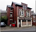
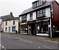
Park Royal House, Clarence Street, Pontypool
The office of chartered accountants Peter Price & Company.
Image: © Jaggery
Taken: 3 Nov 2015
0.00 miles
2
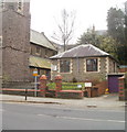
Mount Pleasant Welsh Revival Centre, Pontypool
Viewed across Clarence Street. In November 2015, the nameboard shows
MOUNT PLEASANT WELSH REVIVAL CENTRE.
The church is a a free evangelical church, for the use to all faiths.
The building was previously a United Reformed church.
Image: © Jaggery
Taken: 3 Nov 2015
0.01 miles
3
Northeast side of Mount Pleasant Welsh Revival Centre, Pontypool
http://www.geograph.org.uk/photo/4726582 to another view and a few details.
Image: © Jaggery
Taken: 3 Nov 2015
0.01 miles
4
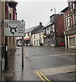
Directions sign in Pontypool town centre
The English/Welsh sign faces southbound traffic in Clarence Street.
Image: © Jaggery
Taken: 28 Jun 2017
0.01 miles
5
Boarded-up shopfront, Clarence Street, Pontypool
Viewed from the corner of Trosnant Street in November 2015.
A May 2011 Google Earth Street View shows a very similar scene of dereliction.
Image: © Jaggery
Taken: 3 Nov 2015
0.01 miles
6
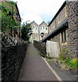
Path to Mount Pleasant Manse & Annexe, Pontypool
Ascending from Clarence Street.
Image: © Jaggery
Taken: 26 Jul 2020
0.02 miles
7
Afon Lwyd flows through Pontypool Park
The view downstream from a footbridge across the Afon Lwyd which flows through the western and southern edges of Pontypool Park.
Image: © Jaggery
Taken: 26 Jan 2011
0.02 miles
8
Mount Pleasant Church, Pontypool
Grade II listed church on Hanbury Road, on the SE side of Pontypool town centre.
It was built as a United Reformed church, with seating for about 550. After a period of dereliction when dwindling congregations led to the closure of the church, a local vicar bought the building and has restored and renovated it. It is now a free evangelical church, open to all faiths to use. The name board near the entrance shows
"Mount Pleasant Welsh Revival Centre.
Available for conferences, weddings/renewal of vows, child dedications, music events."
Image: © Jaggery
Taken: 26 Jan 2011
0.02 miles
9
Seedtime & Harvest Church, Pontypool
Small church building on Hanbury Road, next door to Mount Pleasant Church. http://www.geograph.org.uk/photo/2251461
Image: © Jaggery
Taken: 26 Jan 2011
0.02 miles
10
Darren Lewis, Pontypool
The hair salon in Clarence Street faces Trosnant Street.
Golden Star Chinese restaurant & takeaway is next door.
Image: © Jaggery
Taken: 3 Nov 2015
0.02 miles


