IMAGES TAKEN NEAR TO
Albion Road, PONTYPOOL, NP4 6LJ
Introduction
This page details the photographs taken nearby to Albion Road, NP4 6LJ by members of the Geograph project.
The Geograph project started in 2005 with the aim of publishing, organising and preserving representative images for every square kilometre of Great Britain, Ireland and the Isle of Man.

There are currently over 7.5m images from over14,400 individuals and you can help contribute to the project by visiting https://www.geograph.org.uk
Image Map
Images are licensed for reuse under creativecommons.org/licenses/by-sa/2.0
Notes
- Clicking on the map will re-center to the selected point.
- The higher the marker number, the further away the image location is from the centre of the postcode.
Image Listing (142 Images Found)
Images are licensed for reuse under creativecommons.org/licenses/by-sa/2.0
Image
Details
Distance
1
Side view of the Hog & Hosper, Pontypool
This view of the pub http://www.geograph.org.uk/photo/2426776 is across Albion Road.
Image: © Jaggery
Taken: 25 May 2011
0.01 miles
2
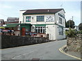
Hog & Hosper, Pontypool
Viewed from Albion Road looking up Crumlin Street. The pub sign portrays a hog with a guitar, in front of a keyboard. This is a reference to the live music nights here, every Friday and Saturday. Wednesdays are Curry Nights and Thursdays for karaoke.
The Hosper part of the name is short for The Hospitality, the former name of the pub.
Image: © Jaggery
Taken: 25 May 2011
0.01 miles
3
Unnamed side street west of Crumlin Street, Pontypool
Leading to the backs of houses in Coedcae Place.
Image: © Jaggery
Taken: 27 Jan 2015
0.02 miles
4
The Dragonffli, Pontypool
The Dragonffli bar and live music venue on the corner of Crumlin Street and Albion Road was
previously the Hog & Hosper. Dragonffli is pseudo Welsh. Dragonfly in Welsh is gwas y neidr.
Image: © Jaggery
Taken: 27 Jan 2015
0.02 miles
5
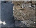
Ordnance Survey Cut Mark
This OS cut mark can be found on the wall at the junction of Albion Road and Crumlin Street. It marks a point 152.144m above mean sea level.
Image: © Adrian Dust
Taken: 7 Jul 2019
0.03 miles
6
Coed Cae Place, Pontypool
Viewed from the Crumlin Street end. Coed Cae Place leads to Woodview Terrace.
Image: © Jaggery
Taken: 27 Jan 2015
0.04 miles
7
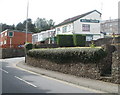
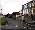
Bryngwyn Road houses, Pontypool
The view is towards High Street.
Image: © Jaggery
Taken: 16 May 2011
0.05 miles
8
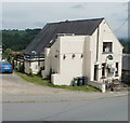
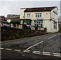
The Bell Inn, Pontypool
Located on a sharp bend in High Street.
Image: © Jaggery
Taken: 16 May 2011
0.05 miles
9
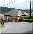
Bungalow on a bend in High Street, Pontypool
The bungalow is opposite The Bell Inn. http://www.geograph.org.uk/photo/2417289
Image: © Jaggery
Taken: 16 May 2011
0.05 miles
10
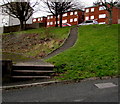
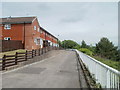
Steps and path from Crumlin Street to Coed Cae Place, Pontypool
Image: © Jaggery
Taken: 27 Jan 2015
0.05 miles