IMAGES TAKEN NEAR TO
Upper Bridge Street, PONTYPOOL, NP4 6JY
Introduction
This page details the photographs taken nearby to Upper Bridge Street, NP4 6JY by members of the Geograph project.
The Geograph project started in 2005 with the aim of publishing, organising and preserving representative images for every square kilometre of Great Britain, Ireland and the Isle of Man.

There are currently over 7.5m images from over14,400 individuals and you can help contribute to the project by visiting https://www.geograph.org.uk
Image Map
Images are licensed for reuse under creativecommons.org/licenses/by-sa/2.0
Notes
- Clicking on the map will re-center to the selected point.
- The higher the marker number, the further away the image location is from the centre of the postcode.
Image Listing (561 Images Found)
Images are licensed for reuse under creativecommons.org/licenses/by-sa/2.0
Image
Details
Distance
1
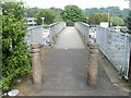
Footbridge to Tesco Pontypool
Viewed from Upper Park Terrace. The footbridge crosses over the A4043 to a Tesco superstore. http://www.geograph.org.uk/photo/2437854
Image: © Jaggery
Taken: 16 May 2011
0.03 miles
2
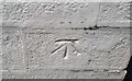
Ordnance Survey Cut Mark
This OS cut mark can be found on the gatepost of the Methodist Chapel, Nicholas Street. It marks a point 156.734m above mean sea level,
Image: © Adrian Dust
Taken: 7 Jul 2019
0.04 miles
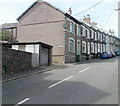
3
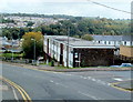
High Street flats, Pontypool
Viewed from the corner of Upper Bridge Street.
Image: © Jaggery
Taken: 23 Sep 2011
0.04 miles
4
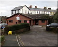
Unite office in Pontypool
Trade union office set back from the east side of High Street.
Image: © Jaggery
Taken: 27 Jan 2015
0.05 miles
5
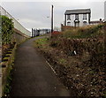
Path to Upper Park Terrace, Pontypool
The fences on the left are at the edge of the A4043.
Image: © Jaggery
Taken: 27 Jan 2015
0.05 miles
6
John Street, Pontypool
Houses on the west side of the street, viewed from Albion Road. The opposite side of the street is occupied by the perimeters of Lower Park Terrace houses.
Image: © Jaggery
Taken: 25 May 2011
0.05 miles
7
Capel Street, Pontypool
Viewed from the Crumlin Street end looking east towards Nicholas Street.
Image: © Jaggery
Taken: 27 Jan 2015
0.06 miles
8
John Street cold calling control zone, Pontypool
Near the Albion Road junction, the sign on the left shows COLD CALLING CONTROL ZONE. This is one of many such zones in Torfaen. The Torfaen County Borough Council website states that in an effort to increase its effectiveness in combating doorstep crime, Torfaen Trading Standards have introduced Cold Calling Control Zones.
What is a Cold Calling Control Zone?
Doorstep crime includes all aspects of consumer detriment and crime arising from doorstep callers. This includes rogue workmen, high pressure sales people, bogus officials and distraction burglary, and it is well established that rogue traders and distraction burglary are often interrelated. In 2002 a national survey conducted by the Trading Standards Institute reported that 96% of people did not want doorstep cold callers and nobody actually welcomed them. 62% of those questioned reported receiving a cold caller in the previous three months.
It is not illegal to make an initial cold call, and a Cold Calling Control Zone has no legal status. However, new legislation has created offences for repeat callers and by working in partnership, such Zones give residents the confidence to say NO to individuals calling on them without a prearranged appointment, and gives the clear message that rogue traders and bogus callers are not welcome in the area.
Many bona fide businesses will make life easier for residents by simply popping a catalogue through the door. This avoids any feelings of confrontation on the doorstep and leaves the decision up to the individual as to whether to buy goods etc from the business concerned.
How does a Cold Calling Control Zone operate?
The Cold Calling Control Zone is very much a partnership initiative between Torfaen County Borough Council, Gwent Police and most importantly local residents themselves. The points of entry into the area will be designated by the placing of lamppost signs, and residents can reinforce the message by placing a sticker in a window close to the front door.
Image: © Jaggery
Taken: 27 Jan 2015
0.06 miles
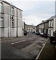
9
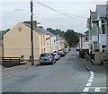
Upper Bridge Street, Pontypool
Viewed from the corner of Crumlin Street.
Image: © Jaggery
Taken: 16 May 2011
0.06 miles
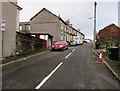
10
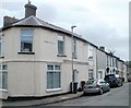
Nicholas Street, Pontypool
This is the NE corner of Nicholas Street, viewed from the edge of Upper Bridge Street.
Image: © Jaggery
Taken: 16 May 2011
0.06 miles