IMAGES TAKEN NEAR TO
Upper Park Terrace, PONTYPOOL, NP4 6JX
Introduction
This page details the photographs taken nearby to Upper Park Terrace, NP4 6JX by members of the Geograph project.
The Geograph project started in 2005 with the aim of publishing, organising and preserving representative images for every square kilometre of Great Britain, Ireland and the Isle of Man.

There are currently over 7.5m images from over14,400 individuals and you can help contribute to the project by visiting https://www.geograph.org.uk
Image Map
Images are licensed for reuse under creativecommons.org/licenses/by-sa/2.0
Notes
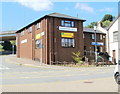
- Clicking on the map will re-center to the selected point.
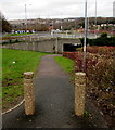
- The higher the marker number, the further away the image location is from the centre of the postcode.
Image Listing (615 Images Found)
Images are licensed for reuse under creativecommons.org/licenses/by-sa/2.0
Image
Details
Distance
1
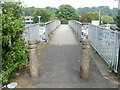
Footbridge to Tesco Pontypool
Viewed from Upper Park Terrace. The footbridge crosses over the A4043 to a Tesco superstore. http://www.geograph.org.uk/photo/2437854
Image: © Jaggery
Taken: 16 May 2011
0.01 miles
2
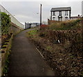
Path to Upper Park Terrace, Pontypool
The fences on the left are at the edge of the A4043.
Image: © Jaggery
Taken: 27 Jan 2015
0.02 miles
3
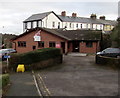
Unite office in Pontypool
Trade union office set back from the east side of High Street.
Image: © Jaggery
Taken: 27 Jan 2015
0.03 miles
4
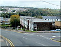
High Street flats, Pontypool
Viewed from the corner of Upper Bridge Street.
Image: © Jaggery
Taken: 23 Sep 2011
0.03 miles
5
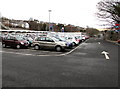
Top Car Park, Lower Bridge Street, Pontypool
Car park in front of the Pontypool Tesco superstore. http://www.geograph.org.uk/photo/4328541
Image: © Jaggery
Taken: 27 Jan 2015
0.04 miles
6
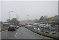
Murky Day at Tesco, Pontypool
The rain was pouring down and the skies were leaden grey and there was a queue of cars on the ramp into Tescos from the A4043.
Image: © Nigel Mykura
Taken: 21 Nov 2014
0.04 miles
7
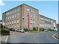
Pontypool Police Station
The SE corner of the station, viewed across Glantorvaen Road. The entrance http://www.geograph.org.uk/photo/2505463 is on the far side.
Image: © Jaggery
Taken: 14 Jul 2011
0.05 miles
8
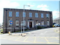
Entrance to Pontypool Police Station
This view from Market Street doesn't convey the size of the building, but this one http://www.geograph.org.uk/photo/2505457 does.
Image: © Jaggery
Taken: 14 Jul 2011
0.05 miles
9
Betty's Cafe, Pontypool
Located on the corner of Glantorvaen Road and Market Street, facing the entrance http://www.geograph.org.uk/photo/2505463 to the police station. The premises on the right, at the top of steps, is Parbin Tandoori Takeaway.
Image: © Jaggery
Taken: 14 Jul 2011
0.05 miles
10
Footpath and cycle route towards an underpass, Pontypool
Posts prevent vehicular misuse of the route ahead, part of National Cycle Network route 492.
Image: © Jaggery
Taken: 27 Jan 2015
0.06 miles