IMAGES TAKEN NEAR TO
Prince Street, PONTYPOOL, NP4 6HT
Introduction
This page details the photographs taken nearby to Prince Street, NP4 6HT by members of the Geograph project.
The Geograph project started in 2005 with the aim of publishing, organising and preserving representative images for every square kilometre of Great Britain, Ireland and the Isle of Man.

There are currently over 7.5m images from over14,400 individuals and you can help contribute to the project by visiting https://www.geograph.org.uk
Image Map
Images are licensed for reuse under creativecommons.org/licenses/by-sa/2.0
Notes
- Clicking on the map will re-center to the selected point.
- The higher the marker number, the further away the image location is from the centre of the postcode.
Image Listing (231 Images Found)
Images are licensed for reuse under creativecommons.org/licenses/by-sa/2.0
Image
Details
Distance
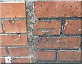
1
Ordnance Survey Cut Mark
This OS cut mark can be found on No14 South View. It marks a point 175.358m above mean sea level.
Image: © Adrian Dust
Taken: 7 Jul 2019
0.05 miles
2
Padre Pio RC primary school, Pontypool
Located on the south side of Conway Road. The school is named after Saint Pio of Pietrelcina (1887– 1968), an Italian Capuchin priest who was canonised by Pope John Paul II in 2002.
The school opened in September 2008, with a transfer of pupils from the now-closed Catholic primary schools of St Alban and St Francis. The £3½ million project was financed jointly by the Roman Catholic Archdiocese of Cardiff, the Welsh Assembly Government and Torfaen Council.
The school has many modern features such as interactive whiteboards in every classroom and a high definition video conferencing unit. There is an outdoor sports playing field, a facility absent from the two previous schools. Environmentally 'green' features include the collection of rain water to flush toilets and a biomass boiler to heat the building.
Image: © Jaggery
Taken: 16 May 2011
0.08 miles
3
King Street, Pontypool
Viewed across Conway Road.
Image: © Jaggery
Taken: 23 Sep 2011
0.09 miles
4
Queen Street, Pontypool
Viewed from the Conway Road end.
Image: © Jaggery
Taken: 23 Sep 2011
0.10 miles
5
Ordnance Survey Cut Mark
This OS cut mark can be found on No15 Conway Road. It marks a point 167.927m above mean sea level.
Image: © Adrian Dust
Taken: 7 Jul 2019
0.10 miles
6
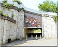
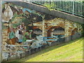
Rugby mosaic, George Street, Pontypool
The mosaic http://www.geograph.org.uk/photo/2393145 is on the George Street side of the A4043 underpass.
Completed in 1993, the mosaic depicts composite scenes of a manoeuvre in a rugby match between Pontypool RFC (in red,white and black kit), and one of their main rivals, Newport RFC. Pontypool RFC are depicted scoring a try at the end of the manoeuvre.
Also depicted, on the left side of the mural, are players from the earlier years of Pontypool RFC, which dates its origins to 1868, though there is no surviving documentation to substantiate the date.
Image: © Jaggery
Taken: 4 May 2011
0.12 miles
7
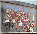
Closeup view of rugby mosaic, Pontypool
The mosaic is on the George Street side http://www.geograph.org.uk/photo/2393045 of an A4043 underpass.
Image: © Jaggery
Taken: 4 May 2011
0.12 miles
8
Mosaic on the west side of A4043 underpass, Pontypool
This mosaic, http://www.geograph.org.uk/photo/2393196 and the rugby mosaic http://www.geograph.org.uk/photo/2393045 on the other side of the underpass, were installed in 1993. Depicted is laundry day at the riverside, as it might have been two hundred or more years ago.
Image: © Jaggery
Taken: 4 May 2011
0.12 miles
9
Washday mosaic detail, Pontypool
A closeup of a mosaic http://www.geograph.org.uk/photo/2393188 on the side of an underpass beneath the A4043.
Image: © Jaggery
Taken: 4 May 2011
0.12 miles
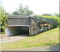
10
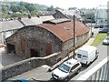
Malthouse Lane warehouse, Pontypool
The rusty-roofed warehouse is viewed from a footpath that ascends from Malthouse Lane to the A4043.
Image: © Jaggery
Taken: 4 May 2011
0.12 miles