1
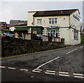
Side view of the Hog & Hosper, Pontypool
This view of the pub http://www.geograph.org.uk/photo/2426776 is across Albion Road.
Image: © Jaggery
Taken: 25 May 2011
0.02 miles
2
Hog & Hosper, Pontypool
Viewed from Albion Road looking up Crumlin Street. The pub sign portrays a hog with a guitar, in front of a keyboard. This is a reference to the live music nights here, every Friday and Saturday. Wednesdays are Curry Nights and Thursdays for karaoke.
The Hosper part of the name is short for The Hospitality, the former name of the pub.
Image: © Jaggery
Taken: 25 May 2011
0.02 miles
3
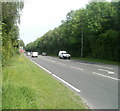
A472 east of Albion Road, Pontypool
Looking in the direction of Pontypool Roundabout from the southern edge of Albion Road.
Image: © Jaggery
Taken: 25 May 2011
0.05 miles
4
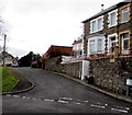
Unnamed side street west of Crumlin Street, Pontypool
Leading to the backs of houses in Coedcae Place.
Image: © Jaggery
Taken: 27 Jan 2015
0.05 miles
5
The Dragonffli, Pontypool
The Dragonffli bar and live music venue on the corner of Crumlin Street and Albion Road was
previously the Hog & Hosper. Dragonffli is pseudo Welsh. Dragonfly in Welsh is gwas y neidr.
Image: © Jaggery
Taken: 27 Jan 2015
0.05 miles
6
Ordnance Survey Cut Mark
This OS cut mark can be found on the wall at the junction of Albion Road and Crumlin Street. It marks a point 152.144m above mean sea level.
Image: © Adrian Dust
Taken: 7 Jul 2019
0.05 miles
7
Albion Road flats, Pontypool
3-storey blocks of flats on the north side of Albion Road, to the west of the Hog & Hosper pub. http://www.geograph.org.uk/photo/2426776
Image: © Jaggery
Taken: 25 May 2011
0.05 miles
8
Ty Glyn, Albion Road, Pontypool
The single-storey building is a Pontypool office of Careers Wales, who provide free, bilingual, impartial careers information, advice and guidance to anyone seeking work.
Image: © Jaggery
Taken: 25 May 2011
0.07 miles
9
Coed Cae Place, Pontypool
Viewed from the Crumlin Street end. Coed Cae Place leads to Woodview Terrace.
Image: © Jaggery
Taken: 27 Jan 2015
0.07 miles
10
The Unicorn, Albion Road, Pontypool
Pub on the south side of Albion Road, between the turnings for John Street and Nicholas Street. There is another Unicorn pub in Pontypool, in Cwmynyscoy. http://www.geograph.org.uk/photo/2461941
Image: © Jaggery
Taken: 16 May 2011
0.08 miles


