IMAGES TAKEN NEAR TO
High Street, PONTYPOOL, NP4 6EY
Introduction
This page details the photographs taken nearby to High Street, NP4 6EY by members of the Geograph project.
The Geograph project started in 2005 with the aim of publishing, organising and preserving representative images for every square kilometre of Great Britain, Ireland and the Isle of Man.

There are currently over 7.5m images from over14,400 individuals and you can help contribute to the project by visiting https://www.geograph.org.uk
Image Map
Images are licensed for reuse under creativecommons.org/licenses/by-sa/2.0
Notes
- Clicking on the map will re-center to the selected point.
- The higher the marker number, the further away the image location is from the centre of the postcode.
Image Listing (574 Images Found)
Images are licensed for reuse under creativecommons.org/licenses/by-sa/2.0
Image
Details
Distance
1
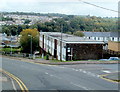
High Street flats, Pontypool
Viewed from the corner of Upper Bridge Street.
Image: © Jaggery
Taken: 23 Sep 2011
0.02 miles
2
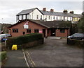
Unite office in Pontypool
Trade union office set back from the east side of High Street.
Image: © Jaggery
Taken: 27 Jan 2015
0.03 miles
3
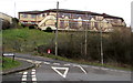
East side of Pontypool Workingmens Club
Viewed from Upper Bridge Street. The club is located in Broadway at the corner of High Street. To the exasperation of grammatical purists, there is no apostrophe before the s in 'Workingmens' on the name sign.
Image: © Jaggery
Taken: 27 Jan 2015
0.04 miles
4
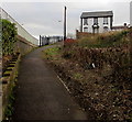
Path to Upper Park Terrace, Pontypool
The fences on the left are at the edge of the A4043.
Image: © Jaggery
Taken: 27 Jan 2015
0.04 miles
5
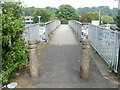
Footbridge to Tesco Pontypool
Viewed from Upper Park Terrace. The footbridge crosses over the A4043 to a Tesco superstore. http://www.geograph.org.uk/photo/2437854
Image: © Jaggery
Taken: 16 May 2011
0.05 miles
6
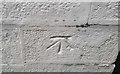
Ordnance Survey Cut Mark
This OS cut mark can be found on the gatepost of the Methodist Chapel, Nicholas Street. It marks a point 156.734m above mean sea level,
Image: © Adrian Dust
Taken: 7 Jul 2019
0.06 miles
7
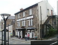
The Globe Hotel, Pontypool
Pub at the southern end of Crane Street, opposite Argos. http://www.geograph.org.uk/photo/2437305 B&B (bed and breakfast) accommodation is available.
Image: © Jaggery
Taken: 1 Jun 2011
0.06 miles
8
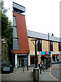
Argos, Pontypool
In Crane Street with conveniently located bus stops and shelters.
Image: © Jaggery
Taken: 1 Jun 2011
0.06 miles
9
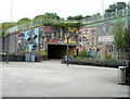
Pontypool japanware mosaic
Located on the wall alongside a pedestrian underpass beneath the A4043, between the southern end of Crane Street and the Tesco superstore. The explanatory text on the wall states
PONTYPOOL JAPANWARE
1732-1817
In the 16th century, Japanese lacquered furniture became fashionable. In Pontypool, locally produced tin plate was decorated in the 'Japan way'. At John Hanbury's works, Thomas Allgood discovered a material which created a brilliant hard lacquer on the metal. By 1732, the first small-scale production of japanware had begun.
Candlesticks, tea trays, butter dishes, powder boxes and small domestic items were produced, decorated in imitation tortoiseshell with gilded Chinese landscapes, figures or floral designs. Pontypool wares were expensive, being of high quality and time-consuming to produce, but were popular all over the world. This mural was produced in 1993 to commemorate this famous local product.
Image: © Jaggery
Taken: 1 Jun 2011
0.06 miles
10
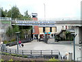
Welcome to Pontypool Shops and Indoor Market
The welcome in English and Welsh is on the side of the bridge carrying a Tesco superstore access road. Ahead is Crane Street. At the left edge of the view is a japanware mural. http://www.geograph.org.uk/photo/2437333. In the middle is an Argos store. http://www.geograph.org.uk/photo/2437305 The black stairway at centre right is part of The Globe Hotel. http://www.geograph.org.uk/photo/2437291
Image: © Jaggery
Taken: 1 Jun 2011
0.06 miles