IMAGES TAKEN NEAR TO
Gwent Street, PONTYPOOL, NP4 6EX
Introduction
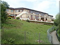
This page details the photographs taken nearby to Gwent Street, NP4 6EX by members of the Geograph project.
The Geograph project started in 2005 with the aim of publishing, organising and preserving representative images for every square kilometre of Great Britain, Ireland and the Isle of Man.

There are currently over 7.5m images from over14,400 individuals and you can help contribute to the project by visiting https://www.geograph.org.uk
Image Map
Images are licensed for reuse under creativecommons.org/licenses/by-sa/2.0
Notes
- Clicking on the map will re-center to the selected point.
- The higher the marker number, the further away the image location is from the centre of the postcode.
Image Listing (181 Images Found)
Images are licensed for reuse under creativecommons.org/licenses/by-sa/2.0
Image
Details
Distance
1
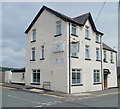
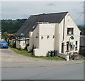
Jewel Balti, Pontypool
Restaurant on the corner of High Street and North Road, formerly the Forgehammer pub.
Image: © Jaggery
Taken: 16 May 2011
0.03 miles
2
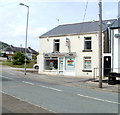
The Chippy, High Street, Pontypool
Takeaway for fish & chips, roast chicken, hot dogs and burgers.
Out of shot on the right, its neighbour was formerly the Colliers Arms pub, now closed.
Image: © Jaggery
Taken: 16 May 2011
0.03 miles
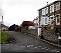
3
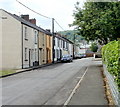
Gwent Street, Pontypool
Houses on the south side of the street, viewed from the Bryngwyn Road side.
Image: © Jaggery
Taken: 16 May 2011
0.04 miles
4
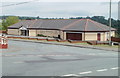
Pontypool Workingmens Club
A modern single-storey building with a zigzag pattern low perimeter wall, located on Broadway at the corner of High Street. To the exasperation, no doubt, of grammatical purists, there is no apostrophe before the s in 'Workingmens'.
Image: © Jaggery
Taken: 16 May 2011
0.05 miles
5
Path north from High Street, Pontypool
On the east side of Pontypool Workingmens Club, http://www.geograph.org.uk/photo/2417242 is a path from High Street to Broadway.
Image: © Jaggery
Taken: 16 May 2011
0.05 miles
6
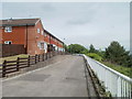
Bryngwyn Road houses, Pontypool
The view is towards High Street.
Image: © Jaggery
Taken: 16 May 2011
0.06 miles
7
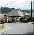
The Bell Inn, Pontypool
Located on a sharp bend in High Street.
Image: © Jaggery
Taken: 16 May 2011
0.06 miles
8
Bungalow on a bend in High Street, Pontypool
The bungalow is opposite The Bell Inn. http://www.geograph.org.uk/photo/2417289
Image: © Jaggery
Taken: 16 May 2011
0.06 miles
9
Coed Cae Place, Pontypool
Viewed from the Crumlin Street end. Coed Cae Place leads to Woodview Terrace.
Image: © Jaggery
Taken: 27 Jan 2015
0.07 miles
10
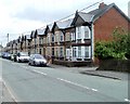
Wern Terrace, High Street, Pontypool
This row of houses on the south side of High Street is named Wern Terrace. The houses are numbered separately from surrounding houses on High Street.
Image: © Jaggery
Taken: 16 May 2011
0.08 miles