IMAGES TAKEN NEAR TO
Avalon Place, PONTYPOOL, NP4 6ES
Introduction
This page details the photographs taken nearby to Avalon Place, NP4 6ES by members of the Geograph project.
The Geograph project started in 2005 with the aim of publishing, organising and preserving representative images for every square kilometre of Great Britain, Ireland and the Isle of Man.

There are currently over 7.5m images from over14,400 individuals and you can help contribute to the project by visiting https://www.geograph.org.uk
Image Map
Images are licensed for reuse under creativecommons.org/licenses/by-sa/2.0
Notes
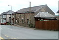
- Clicking on the map will re-center to the selected point.
- The higher the marker number, the further away the image location is from the centre of the postcode.
Image Listing (31 Images Found)
Images are licensed for reuse under creativecommons.org/licenses/by-sa/2.0
Image
Details
Distance
1
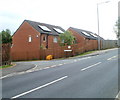
Solar panels, Avalon Court, Pontypool
Viewed across Penywain Lane. The solar panels are not ideally located, facing west.
Image: © Jaggery
Taken: 16 May 2011
0.03 miles
2
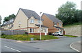
Modern houses, Penywain Lane, Tranch, Pontypool
Houses built in the first decade of the 21st century, on the west side of Penywain Lane.
Image: © Jaggery
Taken: 16 May 2011
0.04 miles
3
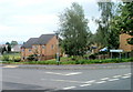
Avalon Court houses, Pontypool
Houses at the northern edge of Avalon Court, near the corner of Conway Road and Penywain Lane.
District boundaries are not signposted in this area. The location is either the southern edge of Wainfelin, or the northern edge of Tranch.
Image: © Jaggery
Taken: 16 May 2011
0.05 miles
4
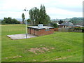
Tranch AFC changing rooms, Pontypool
The building is at the SW edge of the football club's pitch http://www.geograph.org.uk/photo/2415031 on the east side of Penywain Lane.
Image: © Jaggery
Taken: 16 May 2011
0.08 miles
5
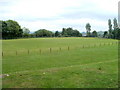
Tranch AFC football ground, Pontypool
The ground is on the east side of Penywain Lane, the home venue for Tranch AFC, an amateur football club.
Image: © Jaggery
Taken: 16 May 2011
0.08 miles
6
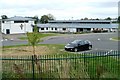
Padre Pio RC primary school, Pontypool
Located on the south side of Conway Road. The school is named after Saint Pio of Pietrelcina (1887– 1968), an Italian Capuchin priest who was canonised by Pope John Paul II in 2002.
The school opened in September 2008, with a transfer of pupils from the now-closed Catholic primary schools of St Alban and St Francis. The £3½ million project was financed jointly by the Roman Catholic Archdiocese of Cardiff, the Welsh Assembly Government and Torfaen Council.
The school has many modern features such as interactive whiteboards in every classroom and a high definition video conferencing unit. There is an outdoor sports playing field, a facility absent from the two previous schools. Environmentally 'green' features include the collection of rain water to flush toilets and a biomass boiler to heat the building.
Image: © Jaggery
Taken: 16 May 2011
0.09 miles
7
The Betting Shop, Tranch, Pontypool
Premises of Allen Jenkins Bookmakers, on the corner of Tranch Road and Twmpath Road.
Some maps show Twympath Road, but the road name sign disagrees.
Image: © Jaggery
Taken: 16 May 2011
0.14 miles
8
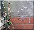
Ordnance Survey Cut Mark
This OS cut mark can be found on the Labour in Vain PH. It marks a point 187.382m above mean sea level.
Image: © Adrian Dust
Taken: 7 Jul 2019
0.15 miles
9
Wainfelin and Pentranch Community Hall, Pontypool
Located on Tranch Road, facing Penywain Lane.
Image: © Jaggery
Taken: 16 May 2011
0.15 miles
10
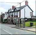
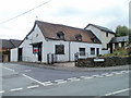
Labour in Vain, Pontypool
Pub located on High Street, Tranch, Pontypool, facing Wern Hill. The pub is currently the headquarters of Tranch AFC, who play their home games nearby. http://www.geograph.org.uk/photo/2415031
Image: © Jaggery
Taken: 16 May 2011
0.16 miles