IMAGES TAKEN NEAR TO
School Lane, PONTYPOOL, NP4 6EH
Introduction
This page details the photographs taken nearby to School Lane, NP4 6EH by members of the Geograph project.
The Geograph project started in 2005 with the aim of publishing, organising and preserving representative images for every square kilometre of Great Britain, Ireland and the Isle of Man.

There are currently over 7.5m images from over14,400 individuals and you can help contribute to the project by visiting https://www.geograph.org.uk
Image Map
Images are licensed for reuse under creativecommons.org/licenses/by-sa/2.0
Notes
- Clicking on the map will re-center to the selected point.
- The higher the marker number, the further away the image location is from the centre of the postcode.
Image Listing (83 Images Found)
Images are licensed for reuse under creativecommons.org/licenses/by-sa/2.0
Image
Details
Distance
1
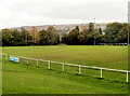
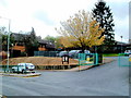
Memorial Ground rugby pitch, Pontypool
The Memorial Ground is home to a rugby union club, Pontypool United RFC
and an amateur rugby league club, the Torfaen Tigers.
Viewed from the Conway Road side of the ground, near the clubhouse. http://www.geograph.org.uk/photo/3370063
Image: © Jaggery
Taken: 23 Sep 2011
0.02 miles
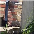
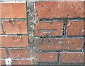
2
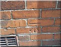
Ordnance Survey Cut Mark
This OS cut mark can be found on No60 Wainfelin Avenue. It marks a point 177.132m above mean sea level.
Image: © Adrian Dust
Taken: 7 Jul 2019
0.05 miles
3
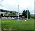
Floodlights and clubhouse, Memorial Ground, Pontypool
Viewed from Conway Road. The Memorial Ground is the home of Pontypool United RFC (Rugby Football Club). This is also the home of local amateur rugby league club, the Torfaen Tigers.
Image: © Jaggery
Taken: 23 Sep 2011
0.06 miles
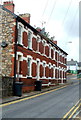
4
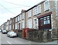
Penywain Terrace, Pontypool
Houses on the south side of the street, viewed from the corner of Penywain Road.
Image: © Jaggery
Taken: 16 May 2011
0.09 miles
5
George Street Primary and Nursery School, Pontypool
The school is in the Wainfelin district of Pontypool.
Image: © Jaggery
Taken: 23 Sep 2011
0.10 miles
6
Ordnance Survey Cut Mark
This OS cut mark can be found on the NE angle of the old Post Office which is now No1 Pennywain Road. It marks a point 187.830m above mean sea level.
Image: © Adrian Dust
Taken: 7 Jul 2019
0.11 miles
7
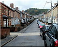
One side only parking, Wainfelin Avenue, Pontypool
There are no double yellow lines to prevent parking, so it must be
a local custom to park vehicles on only one side of Wainfelin Avenue.
Image: © Jaggery
Taken: 23 Sep 2011
0.11 miles
8
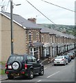
Wainfelin Avenue, Pontypool
Houses on the north side of the street, viewed from the corner of Penywain Road.
Image: © Jaggery
Taken: 16 May 2011
0.12 miles
9
Ordnance Survey Cut Mark
This OS cut mark can be found on No15 Conway Road. It marks a point 167.927m above mean sea level.
Image: © Adrian Dust
Taken: 7 Jul 2019
0.12 miles
10
Amberley Place, Pontypool
Amberley Place is a separately-named row of 4 houses in George Street,
opposite Pontypool Ambulance Station. http://www.geograph.org.uk/photo/3369971
Image: © Jaggery
Taken: 23 Sep 2011
0.13 miles