IMAGES TAKEN NEAR TO
The Avenue, PONTYPOOL, NP4 6EG
Introduction
This page details the photographs taken nearby to The Avenue, NP4 6EG by members of the Geograph project.
The Geograph project started in 2005 with the aim of publishing, organising and preserving representative images for every square kilometre of Great Britain, Ireland and the Isle of Man.

There are currently over 7.5m images from over14,400 individuals and you can help contribute to the project by visiting https://www.geograph.org.uk
Image Map
Images are licensed for reuse under creativecommons.org/licenses/by-sa/2.0
Notes
- Clicking on the map will re-center to the selected point.
- The higher the marker number, the further away the image location is from the centre of the postcode.
Image Listing (22 Images Found)
Images are licensed for reuse under creativecommons.org/licenses/by-sa/2.0
Image
Details
Distance
1
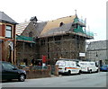
St John the Divine, Pontypool
Reroofing is in progress on the Church in Wales church located on the corner of Penywain Road and St John's Close, Wainfelin, Pontypool.
Image: © Jaggery
Taken: 16 May 2011
0.07 miles
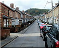
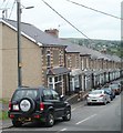
2
Helpstone Terrace houses, Pontypool
Located in the Wainfelin district of Pontypool, viewed across Penywain Road.
Image: © Jaggery
Taken: 16 May 2011
0.08 miles
3
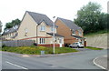
Avalon Court houses, Pontypool
Houses at the northern edge of Avalon Court, near the corner of Conway Road and Penywain Lane.
District boundaries are not signposted in this area. The location is either the southern edge of Wainfelin, or the northern edge of Tranch.
Image: © Jaggery
Taken: 16 May 2011
0.10 miles
4
One side only parking, Wainfelin Avenue, Pontypool
There are no double yellow lines to prevent parking, so it must be
a local custom to park vehicles on only one side of Wainfelin Avenue.
Image: © Jaggery
Taken: 23 Sep 2011
0.11 miles
5
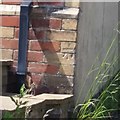
Ordnance Survey Cut Mark
This OS cut mark can be found on the NE angle of the old Post Office which is now No1 Pennywain Road. It marks a point 187.830m above mean sea level.
Image: © Adrian Dust
Taken: 7 Jul 2019
0.11 miles
6
Modern houses, Penywain Lane, Tranch, Pontypool
Houses built in the first decade of the 21st century, on the west side of Penywain Lane.
Image: © Jaggery
Taken: 16 May 2011
0.12 miles
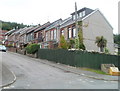
7
Wainfelin Avenue, Pontypool
Houses on the north side of the street, viewed from the corner of Penywain Road.
Image: © Jaggery
Taken: 16 May 2011
0.13 miles
8
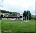
Floodlights and clubhouse, Memorial Ground, Pontypool
Viewed from Conway Road. The Memorial Ground is the home of Pontypool United RFC (Rugby Football Club). This is also the home of local amateur rugby league club, the Torfaen Tigers.
Image: © Jaggery
Taken: 23 Sep 2011
0.13 miles
9
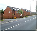
Solar panels, Avalon Court, Pontypool
Viewed across Penywain Lane. The solar panels are not ideally located, facing west.
Image: © Jaggery
Taken: 16 May 2011
0.15 miles
10
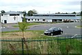
Padre Pio RC primary school, Pontypool
Located on the south side of Conway Road. The school is named after Saint Pio of Pietrelcina (1887– 1968), an Italian Capuchin priest who was canonised by Pope John Paul II in 2002.
The school opened in September 2008, with a transfer of pupils from the now-closed Catholic primary schools of St Alban and St Francis. The £3½ million project was financed jointly by the Roman Catholic Archdiocese of Cardiff, the Welsh Assembly Government and Torfaen Council.
The school has many modern features such as interactive whiteboards in every classroom and a high definition video conferencing unit. There is an outdoor sports playing field, a facility absent from the two previous schools. Environmentally 'green' features include the collection of rain water to flush toilets and a biomass boiler to heat the building.
Image: © Jaggery
Taken: 16 May 2011
0.15 miles