1
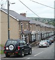
One side only parking, Wainfelin Avenue, Pontypool
There are no double yellow lines to prevent parking, so it must be
a local custom to park vehicles on only one side of Wainfelin Avenue.
Image: © Jaggery
Taken: 23 Sep 2011
0.02 miles
2
St John the Divine, Pontypool
Reroofing is in progress on the Church in Wales church located on the corner of Penywain Road and St John's Close, Wainfelin, Pontypool.
Image: © Jaggery
Taken: 16 May 2011
0.02 miles
3
Ordnance Survey Cut Mark
This OS cut mark can be found on the NE angle of the old Post Office which is now No1 Pennywain Road. It marks a point 187.830m above mean sea level.
Image: © Adrian Dust
Taken: 7 Jul 2019
0.03 miles
4
Wainfelin Avenue, Pontypool
Houses on the north side of the street, viewed from the corner of Penywain Road.
Image: © Jaggery
Taken: 16 May 2011
0.04 miles
5
Helpstone Terrace houses, Pontypool
Located in the Wainfelin district of Pontypool, viewed across Penywain Road.
Image: © Jaggery
Taken: 16 May 2011
0.06 miles
6
Ordnance Survey Cut Mark
This OS cut mark can be found on No60 Wainfelin Avenue. It marks a point 177.132m above mean sea level.
Image: © Adrian Dust
Taken: 7 Jul 2019
0.10 miles
7
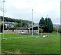
Floodlights and clubhouse, Memorial Ground, Pontypool
Viewed from Conway Road. The Memorial Ground is the home of Pontypool United RFC (Rugby Football Club). This is also the home of local amateur rugby league club, the Torfaen Tigers.
Image: © Jaggery
Taken: 23 Sep 2011
0.11 miles
8
Penywain Terrace, Pontypool
Houses on the south side of the street, viewed from the corner of Penywain Road.
Image: © Jaggery
Taken: 16 May 2011
0.12 miles
9
Memorial Ground rugby pitch, Pontypool
The Memorial Ground is home to a rugby union club, Pontypool United RFC
and an amateur rugby league club, the Torfaen Tigers.
Viewed from the Conway Road side of the ground, near the clubhouse. http://www.geograph.org.uk/photo/3370063
Image: © Jaggery
Taken: 23 Sep 2011
0.13 miles
10
Looking towards Tranch Wood from the edge of Fowler Street, Pontypool
Image: © Jaggery
Taken: 10 May 2011
0.16 miles


