IMAGES TAKEN NEAR TO
St. Johns Crescent, PONTYPOOL, NP4 6DZ
Introduction
This page details the photographs taken nearby to St. Johns Crescent, NP4 6DZ by members of the Geograph project.
The Geograph project started in 2005 with the aim of publishing, organising and preserving representative images for every square kilometre of Great Britain, Ireland and the Isle of Man.

There are currently over 7.5m images from over14,400 individuals and you can help contribute to the project by visiting https://www.geograph.org.uk
Image Map
Images are licensed for reuse under creativecommons.org/licenses/by-sa/2.0
Notes
- Clicking on the map will re-center to the selected point.
- The higher the marker number, the further away the image location is from the centre of the postcode.
Image Listing (96 Images Found)
Images are licensed for reuse under creativecommons.org/licenses/by-sa/2.0
Image
Details
Distance
1
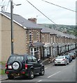
Wainfelin Avenue, Pontypool
Houses on the north side of the street, viewed from the corner of Penywain Road.
Image: © Jaggery
Taken: 16 May 2011
0.05 miles
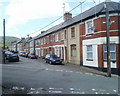
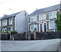
2
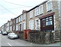
Penywain Terrace, Pontypool
Houses on the south side of the street, viewed from the corner of Penywain Road.
Image: © Jaggery
Taken: 16 May 2011
0.05 miles
3
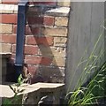
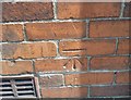
Ordnance Survey Cut Mark
This OS cut mark can be found on the NE angle of the old Post Office which is now No1 Pennywain Road. It marks a point 187.830m above mean sea level.
Image: © Adrian Dust
Taken: 7 Jul 2019
0.06 miles
4
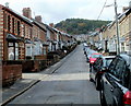
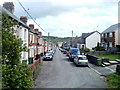
One side only parking, Wainfelin Avenue, Pontypool
There are no double yellow lines to prevent parking, so it must be
a local custom to park vehicles on only one side of Wainfelin Avenue.
Image: © Jaggery
Taken: 23 Sep 2011
0.07 miles
5
Ordnance Survey Cut Mark
This OS cut mark can be found on No60 Wainfelin Avenue. It marks a point 177.132m above mean sea level.
Image: © Adrian Dust
Taken: 7 Jul 2019
0.07 miles
6
Fowler Street, Wainfelin, Pontypool
Houses on the north side of the street viewed from the western end of Wainfelin Road.
Image: © Jaggery
Taken: 10 May 2011
0.08 miles
7
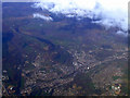
Pontypool from the air
Pontnewynydd is to the right in this view from a Bristol bound flight from Glasgow. The A472 road is to the left.
Image: © Thomas Nugent
Taken: 2 Apr 2012
0.09 miles
8
Looking east along Fowler Street, Wainfelin, Pontypool
The view from an open space at the western end of the street, which runs due east for 175 metres to the junction of Merchant's Hill, Wainfelin Road and Penywain Road. Just out of shot beyond the lower left corner of the view, Fowler Street meets the southern end of Elled Road.
Image: © Jaggery
Taken: 10 May 2011
0.09 miles
9
Wainfelin Road, Pontypool
Houses at the western end of Wainfelin Road viewed from top (SE) end of Merchant's Hill.
Image: © Jaggery
Taken: 10 May 2011
0.09 miles
10

Ordnance Survey Cut Mark
This OS cut mark can be found on No55 Fowler Street. It marks a point 162.175m above mean sea level.
Image: © Adrian Dust
Taken: 7 Jul 2019
0.10 miles