IMAGES TAKEN NEAR TO
George Street, PONTYPOOL, NP4 6BY
Introduction
This page details the photographs taken nearby to George Street, NP4 6BY by members of the Geograph project.
The Geograph project started in 2005 with the aim of publishing, organising and preserving representative images for every square kilometre of Great Britain, Ireland and the Isle of Man.

There are currently over 7.5m images from over14,400 individuals and you can help contribute to the project by visiting https://www.geograph.org.uk
Image Map
Images are licensed for reuse under creativecommons.org/licenses/by-sa/2.0
Notes
- Clicking on the map will re-center to the selected point.
- The higher the marker number, the further away the image location is from the centre of the postcode.
Image Listing (460 Images Found)
Images are licensed for reuse under creativecommons.org/licenses/by-sa/2.0
Image
Details
Distance
1
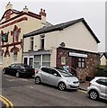
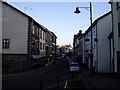
George Street premises to let, Pontypool
There is an estate agents' To Let board on the side wall of 42 George Street,
where the name boards of the former occupier remain.
Next door is the renovated and recently-reopened White Hart. http://www.geograph.org.uk/photo/3329446
Image: © Jaggery
Taken: 11 Feb 2013
0.00 miles
2
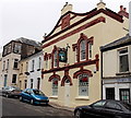
Renovated White Hart, Pontypool
The long disused White Hart Hotel reopened as a bar in December 2012 after being restored with funds from a Townscape Heritage Initiative grant. Here's a pre-restoration view http://www.geograph.org.uk/photo/2393312 from May 2011.
Image: © Jaggery
Taken: 11 Feb 2013
0.01 miles
3
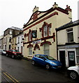
White Hart pub, Pontypool
Viewed across George Street in late January 2017. http://www.geograph.org.uk/photo/5267448 to the name sign.
Image: © Jaggery
Taken: 30 Jan 2017
0.01 miles
4
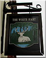
White Hart name sign, George Street, Pontypool
Hanging from a wall bracket here. http://www.geograph.org.uk/photo/5267440
Image: © Jaggery
Taken: 30 Jan 2017
0.01 miles
6
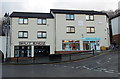
Split Endz, Pontypool
Two George Street businesses are Split Endz hairdressers on the left, Lloyds Pharmacy on the right.
Image: © Jaggery
Taken: 2 Jan 2014
0.01 miles
7

Former Pontypool Fire Station
Now The Hair Cellar, hairstylists, this building at 8 Osborne Road in the centre of Pontypool was the fire station from 1906 to 1952. Pontypool's fire station is now in New Inn. http://www.geograph.org.uk/photo/2245013
Image: © Jaggery
Taken: 4 May 2011
0.02 miles
8

Pontypool Conservative Club
Located on Osborne Road. The year 1894 is inscribed in stone above the doorway.
Image: © Jaggery
Taken: 4 May 2011
0.02 miles
9

Osbourne Lodge Nursery (former Scala cinema) Pontypool
Located on Osborne Road. The name of the nursery is Osbourne, the road is Osborne.
The nursery, for children up to school age, is located in the building that formerly housed a small cinema, the Scala, which had a seating capacity of about 130. The nursery formerly occupied only the basement, but took over the whole building after the Scala closed in 2005.
Image: © Jaggery
Taken: 4 May 2011
0.02 miles
10

The John Capel Hanbury, Pontypool
Wetherspoons pub which opened in 2006 on Osborne Road in the central shopping area of Pontypool.
Since the reign of Elizabeth I (late sixteenth century), the Hanbury family had been closely involved with the development of Pontypool. Richard Hanbury constructed an ironworks and the Hanburys pioneered the production of iron japanware in Pontypool. Japanware http://www.geograph.org.uk/photo/2437333 has a decorated, lacquered style with a hard black gloss.
John Capel Hanbury (1853-1921), sometimes referred to as the last Squire of Pontypool, was a notable benefactor to the town. He donated the sites of Pontypool Hospital, the grammar school, the library, the market and St Hilda's Church. His biggest donation was Pontypool Park, covering about 150 acres (roughly 60 hectares).
Image: © Jaggery
Taken: 4 May 2011
0.02 miles