1
Broadway houses, Pontypool
The houses are on the east side of Broadway.
The bus shelter in the distance is opposite the North Road junction.
Image: © Jaggery
Taken: 23 Sep 2011
0.02 miles
2
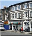
Pontypool Post Office
Located in the central shopping area of Pontypool, at 134 Osborne Road.
Image: © Jaggery
Taken: 4 May 2011
0.03 miles
3
Lloyds Pharmacy, Pontypool
Located at 29 George Street, on the edge of the central shopping area of Pontypool.
Image: © Jaggery
Taken: 4 May 2011
0.03 miles
4
King Street, Pontypool
Viewed across Conway Road.
Image: © Jaggery
Taken: 23 Sep 2011
0.05 miles
5
The White Hart Hotel, Pontypool
Image: © John Lord
Taken: 2 Mar 2011
0.06 miles
6
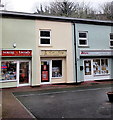
The Courtyard Shops, Pontypool
In view are 3 of the 4 shops in The Courtyard Shops, set back from George Street in the town centre.
Image: © Jaggery
Taken: 11 Feb 2013
0.06 miles
7
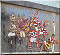
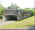
Rugby mosaic, George Street, Pontypool
The mosaic http://www.geograph.org.uk/photo/2393145 is on the George Street side of the A4043 underpass.
Completed in 1993, the mosaic depicts composite scenes of a manoeuvre in a rugby match between Pontypool RFC (in red,white and black kit), and one of their main rivals, Newport RFC. Pontypool RFC are depicted scoring a try at the end of the manoeuvre.
Also depicted, on the left side of the mural, are players from the earlier years of Pontypool RFC, which dates its origins to 1868, though there is no surviving documentation to substantiate the date.
Image: © Jaggery
Taken: 4 May 2011
0.07 miles
8
Closeup view of rugby mosaic, Pontypool
The mosaic is on the George Street side http://www.geograph.org.uk/photo/2393045 of an A4043 underpass.
Image: © Jaggery
Taken: 4 May 2011
0.07 miles
9
Mosaic on the west side of A4043 underpass, Pontypool
This mosaic, http://www.geograph.org.uk/photo/2393196 and the rugby mosaic http://www.geograph.org.uk/photo/2393045 on the other side of the underpass, were installed in 1993. Depicted is laundry day at the riverside, as it might have been two hundred or more years ago.
Image: © Jaggery
Taken: 4 May 2011
0.07 miles
10
Washday mosaic detail, Pontypool
A closeup of a mosaic http://www.geograph.org.uk/photo/2393188 on the side of an underpass beneath the A4043.
Image: © Jaggery
Taken: 4 May 2011
0.07 miles


