IMAGES TAKEN NEAR TO
Twmpath Gardens, PONTYPOOL, NP4 6AU
Introduction
This page details the photographs taken nearby to Twmpath Gardens, NP4 6AU by members of the Geograph project.
The Geograph project started in 2005 with the aim of publishing, organising and preserving representative images for every square kilometre of Great Britain, Ireland and the Isle of Man.

There are currently over 7.5m images from over14,400 individuals and you can help contribute to the project by visiting https://www.geograph.org.uk
Image Map
Images are licensed for reuse under creativecommons.org/licenses/by-sa/2.0
Notes
- Clicking on the map will re-center to the selected point.
- The higher the marker number, the further away the image location is from the centre of the postcode.
Image Listing (51 Images Found)
Images are licensed for reuse under creativecommons.org/licenses/by-sa/2.0
Image
Details
Distance
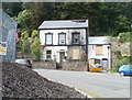
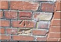
1
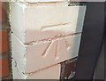
Ordnance Survey Cut Mark
This OS cut mark can be found on No8 Twympath Road. It marks a point 169.344m above mean sea level.
Image: © Adrian Dust
Taken: 7 Jul 2019
0.04 miles
2
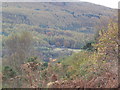
Glyn Pits Pontypool
From Pentranch View Point
Image: © brian walker
Taken: 24 Oct 2008
0.05 miles
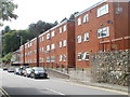
3
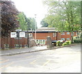
Entrance to Glanwern House, Pontypool
Glanwern House is set below street level at the western end of Bryngwyn Road.
Built in 1977, it contains 27 rented flats. There is a resident management staff and community alarm service. New residents must be aged at least 60.
Image: © Jaggery
Taken: 16 May 2011
0.05 miles
4
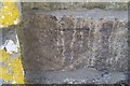
Ordnance Survey Cut Mark
This OS cut mark can be found on the wall at the junction of Twympath Road & Crumlin Road. It marks a point 158.359m above mean sea level.
Image: © Adrian Dust
Taken: 7 Jul 2019
0.06 miles
5
Fire-damaged Albion House, Pontypool
Located at the corner of Albion Road and Crumlin Road. Signs on the abandoned building state CONSTRUCTION SITE - KEEP OUT.
Image: © Jaggery
Taken: 25 May 2011
0.09 miles
6
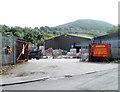
Entrance to Terry Howell depot, Pontypool
A large timber and builders' merchants site with perimeters along the A472 on the south, Crumlin Road on the north, and Albion Road on the east. The entrance to the yard is at the NE edge of the site, from Crumlin Road.
Image: © Jaggery
Taken: 25 May 2011
0.09 miles
7
Southern end of Twmpath Road, Sowhill, Pontypool
Twmpath Road climbs away from the corner of Crumlin Bungalows, heading for High Street, Tranch.
Image: © Jaggery
Taken: 25 May 2011
0.10 miles
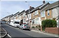
8
Albion Road flats, Pontypool
3-storey blocks of flats on the north side of Albion Road, to the west of the Hog & Hosper pub. http://www.geograph.org.uk/photo/2426776
Image: © Jaggery
Taken: 25 May 2011
0.10 miles
9
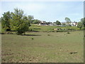
Fields on the north side of Crumlin Bungalows, Pontypool
Crumlin Bungalows is a road in the Sowhill area of Pontypool. Its course is westwards from Twmpath Road, to the eastern edge of Waunwern Park.
Image: © Jaggery
Taken: 25 May 2011
0.10 miles
10
Ordnance Survey Cut Mark
This OS cut mark can be found on the wall of No52 Twympath Road. It marks a point 185.776m above mean sea level.
Image: © Adrian Dust
Taken: 7 Jul 2019
0.10 miles