IMAGES TAKEN NEAR TO
Twmpath Road, PONTYPOOL, NP4 6AQ
Introduction
This page details the photographs taken nearby to Twmpath Road, NP4 6AQ by members of the Geograph project.
The Geograph project started in 2005 with the aim of publishing, organising and preserving representative images for every square kilometre of Great Britain, Ireland and the Isle of Man.

There are currently over 7.5m images from over14,400 individuals and you can help contribute to the project by visiting https://www.geograph.org.uk
Image Map
Images are licensed for reuse under creativecommons.org/licenses/by-sa/2.0
Notes
- Clicking on the map will re-center to the selected point.
- The higher the marker number, the further away the image location is from the centre of the postcode.
Image Listing (52 Images Found)
Images are licensed for reuse under creativecommons.org/licenses/by-sa/2.0
Image
Details
Distance
1
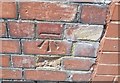
Ordnance Survey Cut Mark
This OS cut mark can be found on the wall of No52 Twympath Road. It marks a point 185.776m above mean sea level.
Image: © Adrian Dust
Taken: 7 Jul 2019
0.03 miles
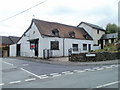
2
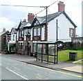
Labour in Vain, Pontypool
Pub located on High Street, Tranch, Pontypool, facing Wern Hill. The pub is currently the headquarters of Tranch AFC, who play their home games nearby. http://www.geograph.org.uk/photo/2415031
Image: © Jaggery
Taken: 16 May 2011
0.04 miles
3
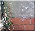
Ordnance Survey Cut Mark
This OS cut mark can be found on the Labour in Vain PH. It marks a point 187.382m above mean sea level.
Image: © Adrian Dust
Taken: 7 Jul 2019
0.06 miles
4
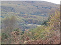
Glyn Pits Pontypool
From Pentranch View Point
Image: © brian walker
Taken: 24 Oct 2008
0.06 miles
5
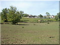
Fields on the north side of Crumlin Bungalows, Pontypool
Crumlin Bungalows is a road in the Sowhill area of Pontypool. Its course is westwards from Twmpath Road, to the eastern edge of Waunwern Park.
Image: © Jaggery
Taken: 25 May 2011
0.06 miles
6
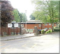
Entrance to Glanwern House, Pontypool
Glanwern House is set below street level at the western end of Bryngwyn Road.
Built in 1977, it contains 27 rented flats. There is a resident management staff and community alarm service. New residents must be aged at least 60.
Image: © Jaggery
Taken: 16 May 2011
0.07 miles
7
The Betting Shop, Tranch, Pontypool
Premises of Allen Jenkins Bookmakers, on the corner of Tranch Road and Twmpath Road.
Some maps show Twympath Road, but the road name sign disagrees.
Image: © Jaggery
Taken: 16 May 2011
0.07 miles
8
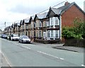
Wern Terrace, High Street, Pontypool
This row of houses on the south side of High Street is named Wern Terrace. The houses are numbered separately from surrounding houses on High Street.
Image: © Jaggery
Taken: 16 May 2011
0.07 miles
9
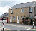
Former post office, High Street, Pontypool
The postbox is the only remaining clue that this was formerly the High Street post office, which closed down in 2003. The main post office in Pontypool is in Osborne Road, http://www.geograph.org.uk/photo/2393356 in the central shopping area of the town.
Image: © Jaggery
Taken: 16 May 2011
0.07 miles
10
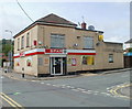
High Street Spar, Pontypool
Located on the corner of High Street and North Road, opposite Jewel Balti. http://www.geograph.org.uk/photo/2417203
Image: © Jaggery
Taken: 16 May 2011
0.07 miles