IMAGES TAKEN NEAR TO
Parc Panteg, PONTYPOOL, NP4 5YJ
Introduction
This page details the photographs taken nearby to Parc Panteg, NP4 5YJ by members of the Geograph project.
The Geograph project started in 2005 with the aim of publishing, organising and preserving representative images for every square kilometre of Great Britain, Ireland and the Isle of Man.

There are currently over 7.5m images from over14,400 individuals and you can help contribute to the project by visiting https://www.geograph.org.uk
Image Map
Images are licensed for reuse under creativecommons.org/licenses/by-sa/2.0
Notes
- Clicking on the map will re-center to the selected point.
- The higher the marker number, the further away the image location is from the centre of the postcode.
Image Listing (108 Images Found)
Images are licensed for reuse under creativecommons.org/licenses/by-sa/2.0
Image
Details
Distance
1
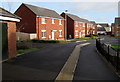
Parc Panteg, Pontypool
On the east side of Avondale Road, Parc Panteg houses are on the site of the demolished Panteg Steelworks.
An electricity substation http://www.geograph.org.uk/photo/4321675 is on the left.
Image: © Jaggery
Taken: 24 Jan 2015
0.03 miles
2
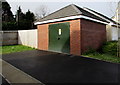
Waterloo Sebastopol electricity substation, Pontypool
The identifier on the Western Power Distribution electricity substation is
WATERLOO SEBASTOPOL S/S No 53-7140. Located on the Avondale Road side of houses in Parc Panteg, this substation was named when this http://www.geograph.org.uk/photo/4321592 nearby building, now Goshen Veterinary Centre, was the Waterloo pub.
Image: © Jaggery
Taken: 24 Jan 2015
0.04 miles
4
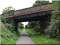
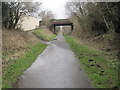
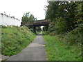
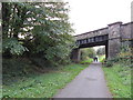
Former railway bridge, Sebastopol, Pontypool
The bridge carries Avondale Road over a path which uses the trackbed http://www.geograph.org.uk/photo/3087688 of a dismantled railway
near the site of the demolished Sebastopol railway station, which closed in 1962.
Image: © Jaggery
Taken: 24 Jan 2015
0.05 miles
5
Sebastopol railway station (site), Gwent
Opened in 1928 by the Great Western Railway on its line from Newport to Pontypool (Crane Street) and Blaenavon, this station closed in 1962.
View north towards Panteg & Griffithstown and Pontypool. It is believed there were two platforms but it is not certain if the descending path on the left was an original entrance path.
Image: © Nigel Thompson
Taken: 14 Mar 2015
0.05 miles
6
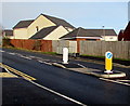
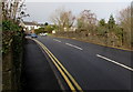
Pedestrian refuge in Avondale Road, Pontypool
Viewed at a rare traffic-free moment on a busy road between Cwmbran and Pontypool. The refuge enables a walker to cross the road in two goes if necessary, without needing to wait for a gap in traffic from both directions.
The small single-storey building behind the railings is an electricity substation. http://www.geograph.org.uk/photo/4321675
Image: © Jaggery
Taken: 24 Jan 2015
0.05 miles
8
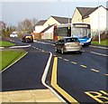
X24 bus, Avondale Road, Pontypool
The Stagecoach bus is on route X24 from Blaenavon to Newport via Pontypool and Cwmbran.
Image: © Jaggery
Taken: 24 Jan 2015
0.06 miles
9
Cycle path / former railway line near Sebastopol
Image: © Gareth James
Taken: 23 Oct 2011
0.06 miles
10
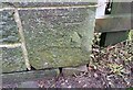
Ordnance Survey Cut Mark
This OS cut mark can be found on the SW parapet of the railway bridge. It marks a point 95.460m above mean sea level.
Image: © Adrian Dust
Taken: 16 Feb 2021
0.06 miles