IMAGES TAKEN NEAR TO
Penyrheol, PONTYPOOL, NP4 5XQ
Introduction
This page details the photographs taken nearby to NP4 5XQ by members of the Geograph project.
The Geograph project started in 2005 with the aim of publishing, organising and preserving representative images for every square kilometre of Great Britain, Ireland and the Isle of Man.

There are currently over 7.5m images from over14,400 individuals and you can help contribute to the project by visiting https://www.geograph.org.uk
Image Map (24 Images)


Leaflet Map data © OpenStreetMap
Images are licensed for reuse under creativecommons.org/licenses/by-sa/2.0
Notes
- Clicking on the map will re-center to the selected point.
- The higher the marker number, the further away the image location is from the centre of the postcode.
Image Listing (24 Images Found)
Images are licensed for reuse under creativecommons.org/licenses/by-sa/2.0
Image
Details
Distance
1
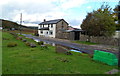
Well Cottage and Well House, Penyrheol
Houses on the NW edge of the hamlet.
Image: © Jaggery
Taken: 26 Oct 2011
0.03 miles
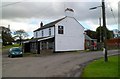
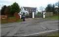
2
Chaintree Cottage, Penyrheol
Located on the north side of the hamlet green.
Image: © Jaggery
Taken: 26 Oct 2011
0.03 miles
3
Cherrytree Cottage, Penyrheol
Located on the west side of the hamlet green.
Image: © Jaggery
Taken: 26 Oct 2011
0.07 miles
4
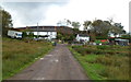
Lamb Inn
Tafarn y Lamb ger Pontypwl yn 1998. Mae llwybr hirbell 'Ffordd y Cambrian' yn mynd heibio iddo.
The Lamb near Pontypool in 1998. The long distance footpath 'The Cambrian Way' runs alongside it.
Image: © Alan Richards
Taken: 28 Jul 1998
0.10 miles
5
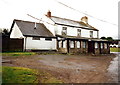
The Lamb, Penyrheol
Pub in the hamlet of Penyrheol, between Pontypool and Cwmbran.
Image: © Jaggery
Taken: 26 Oct 2011
0.11 miles
6
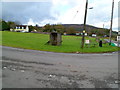
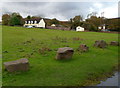
Small concrete structure on the hamlet green, Penyrheol
Located at the NE corner of the hamlet green, facing The Lamb pub. http://www.geograph.org.uk/photo/2666964
The narrow structure is a little under 6 feet high, so is unlikely to have been a bus shelter. What was its use?
Image: © Jaggery
Taken: 26 Oct 2011
0.11 miles
7
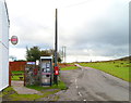
Two postboxes and a phonebox, Penyrheol
Located at the edge of the Lamb pub. http://www.geograph.org.uk/photo/2666964
The only functioning box of the three is the Queen Elizabeth II postbox on a black stand on the right. There is no glass in the sides of the phonebox and the phone does not have a dial tone.
The disused postbox on the left http://www.geograph.org.uk/photo/2666985 is from the reign of George V (1910-1936).
Image: © Jaggery
Taken: 26 Oct 2011
0.11 miles
8
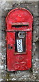
Disused George V postbox, Penyrheol
Located alongside a disused phonebox and the current postbox. http://www.geograph.org.uk/photo/2666980
Image: © Jaggery
Taken: 26 Oct 2011
0.11 miles
9
Oaks Cottages, Penyrheol
Two semi-detached houses on the east side of the hamlet green.
Image: © Jaggery
Taken: 26 Oct 2011
0.11 miles
10
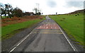
Mountain Road, Penyrheol
Mountain Road heads away from the hamlet of Penyrheol, towards Upper Cwmbran.
Image: © Jaggery
Taken: 26 Oct 2011
0.11 miles