IMAGES TAKEN NEAR TO
Prescoch Lane, PONTYPOOL, NP4 5XG
Introduction
This page details the photographs taken nearby to Prescoch Lane, NP4 5XG by members of the Geograph project.
The Geograph project started in 2005 with the aim of publishing, organising and preserving representative images for every square kilometre of Great Britain, Ireland and the Isle of Man.

There are currently over 7.5m images from over14,400 individuals and you can help contribute to the project by visiting https://www.geograph.org.uk
Image Map
Images are licensed for reuse under creativecommons.org/licenses/by-sa/2.0
Notes
- Clicking on the map will re-center to the selected point.
- The higher the marker number, the further away the image location is from the centre of the postcode.
Image Listing (129 Images Found)
Images are licensed for reuse under creativecommons.org/licenses/by-sa/2.0
Image
Details
Distance
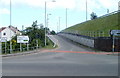
2
Left for Griffithstown, Pontypool
The direction sign is on the SW side of Cwmynyscoy Roundabout. http://www.geograph.org.uk/photo/1578870
Image: © Jaggery
Taken: 27 Jan 2015
0.02 miles
3
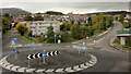
Cwmynyscoy Roundabout, Pontymoel, Pontypool
Viewed from the footbridge over Rockhill Road. On the left is Cwmynyscoy Road ; on the upper right is Victoria Road, heading towards Trosnant.
Image: © Jaggery
Taken: 21 Oct 2009
0.02 miles
4
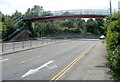
Footbridge near Cwmynyscoy Roundabout, Pontypool
Viewed along the SW end of Rockhill Road, looking towards Cwmynyscoy Roundabout. http://www.geograph.org.uk/photo/1578870
Image: © Jaggery
Taken: 13 Jun 2011
0.02 miles
5
The end of Stafford Road, Pontymoel
Stafford Road heads downs towards its end at Cwmynyscoy roundabout http://www.geograph.org.uk/photo/1578870
Image: © Jaggery
Taken: 21 Oct 2009
0.05 miles
6
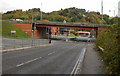
Bus and bus shelters near Cwmynyscoy Roundabout, Pontypool
Headings towards Griffithstown, a Stagecoach bus leaves a bus stop near Cwmynyscoy Roundabout. http://www.geograph.org.uk/photo/1578870
Image: © Jaggery
Taken: 27 Jan 2015
0.06 miles
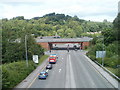
7
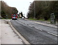
A472 bridge over Rockhill Road, Pontymoel
Rockhill Road heads away from Cwmynyscoy roundabout http://www.geograph.org.uk/photo/1578870 towards the bridge carrying the A472 across it.
Image: © Jaggery
Taken: 21 Oct 2009
0.07 miles
8
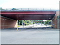
A472 crosses above Rockhill Road, Pontypool
This section of the A472 follows the route of a dismantled railway line. The similarly-coloured bridge in the distance is a footbridge about 125 metres away.
Image: © Jaggery
Taken: 7 Jun 2011
0.07 miles
9
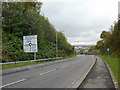
Usk this way (or that way), Rockhill Road, Pontypool
Signs on both sides of the road point to the entrance slip road from Rockhill Road to the SE-bound A472. In you miss this turning and head for New Inn (signposted on the far left) you will very soon reach Usk Road, the older route to that town.
Image: © Jaggery
Taken: 7 Jun 2011
0.07 miles
10
A472 and Rockhill Road, Pontypool
Rockhill Road passes under the A472. Viewed from a footbridge. http://www.geograph.org.uk/photo/2460610
Image: © Jaggery
Taken: 13 Jun 2011
0.07 miles