IMAGES TAKEN NEAR TO
Upper Race, PONTYPOOL, NP4 5UZ
Introduction
This page details the photographs taken nearby to NP4 5UZ by members of the Geograph project.
The Geograph project started in 2005 with the aim of publishing, organising and preserving representative images for every square kilometre of Great Britain, Ireland and the Isle of Man.

There are currently over 7.5m images from over14,400 individuals and you can help contribute to the project by visiting https://www.geograph.org.uk
Image Map
Images are licensed for reuse under creativecommons.org/licenses/by-sa/2.0
Notes
- Clicking on the map will re-center to the selected point.
- The higher the marker number, the further away the image location is from the centre of the postcode.
Image Listing (15 Images Found)
Images are licensed for reuse under creativecommons.org/licenses/by-sa/2.0
Image
Details
Distance
1
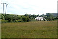
Five Houses, Upper Race, Pontypool
A view from Blaendare Farm Lane http://www.geograph.org.uk/photo/2452794 across a field, towards houses in the imaginatively-named Five Houses area of Upper Race.
Image: © Jaggery
Taken: 9 Jun 2011
0.08 miles
2
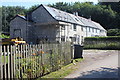
'Five Houses', Upper Race
Building an extension on the end house of the terrace.
Image: © M J Roscoe
Taken: 8 Aug 2020
0.10 miles
3
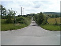
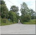
Lane south to Five Houses, Upper Race, Pontypool
The lane heads south from a large turning area http://www.geograph.org.uk/photo/2452743 towards a group of five houses, prosaically named Five Houses.
Image: © Jaggery
Taken: 9 Jun 2011
0.12 miles
4
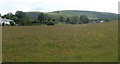
A view from Blaendare Farm Lane, Upper Race, Pontypool
Viewed from the NE edge of Blaendare Farm Lane. http://www.geograph.org.uk/photo/2452794
The houses at the left edge are part of the Five Houses http://www.geograph.org.uk/photo/2452809 area of Upper Race.
Image: © Jaggery
Taken: 9 Jun 2011
0.14 miles
5
Lane to Upper Race houses, Pontypool
A lane (no through road) heads SE away from a large turning area http://www.geograph.org.uk/photo/2452743 towards a small group of houses.
Image: © Jaggery
Taken: 9 Jun 2011
0.16 miles
6
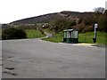
Bus terminus, turning point and crossroads, Upper Race, Pontypool
The bus stop and shelter are at the western edge of an area about 65 metres long and 35 metres across the widest point. Three roads or lanes enter the area from the south. On the northern side, Blaendare Road heading SW, turns through about 200 degrees to become the road heading NNW to Lower Race.
The bus stop is the terminus of Stagecoach bus route 12 to Blaendare from central Pontypool, about 3 kilometres away.
Image: © Jaggery
Taken: 9 Jun 2011
0.17 miles
7
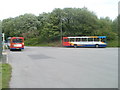
Two Stagecoach buses, Upper Race, Pontypool
The buses are parked in a large turning area, http://www.geograph.org.uk/photo/2452743 the terminus of Stagecoach route 12 from central Pontypool. Neither of the buses are on this route. They both arrived displaying "Not in service", stayed here for about 20 minutes, then left. As it was mid-afternoon, my guess is that the drivers had been on school bus duty, then arrived here for a break, before continuing on to services on other routes.
Image: © Jaggery
Taken: 9 Jun 2011
0.17 miles
8
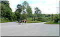
Horse and sulky, Upper Race, Pontypool
While I was waiting at the Blaendare terminus http://www.geograph.org.uk/photo/2452743 for the Stagecoach route 12 bus to central Pontypool, a horse, sulky and driver appeared at speed from Blaendare Road , http://www.geograph.org.uk/photo/2452762, did several circuits of the turning area, then returned along Blaendare Road.
A sulky is a light two-wheeled horse-drawn vehicle for one person.
Image: © Jaggery
Taken: 9 Jun 2011
0.17 miles
9
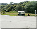
Bus Shelter, Upper Race
Huge turning circle for buses at Upper Race,Twyn Calch can be seen in the background.
Image: © Stuart Wilding
Taken: 11 Mar 2007
0.19 miles
10
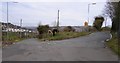
Hairpin bend, Upper Race
One of the more obvious features of this square is this very severe bend.
Image: © Stuart Wilding
Taken: 11 Mar 2007
0.20 miles