IMAGES TAKEN NEAR TO
Lower Race, PONTYPOOL, NP4 5UH
Introduction
This page details the photographs taken nearby to NP4 5UH by members of the Geograph project.
The Geograph project started in 2005 with the aim of publishing, organising and preserving representative images for every square kilometre of Great Britain, Ireland and the Isle of Man.

There are currently over 7.5m images from over14,400 individuals and you can help contribute to the project by visiting https://www.geograph.org.uk
Image Map
Images are licensed for reuse under creativecommons.org/licenses/by-sa/2.0
Notes
- Clicking on the map will re-center to the selected point.
- The higher the marker number, the further away the image location is from the centre of the postcode.
Image Listing (24 Images Found)
Images are licensed for reuse under creativecommons.org/licenses/by-sa/2.0
Image
Details
Distance
1
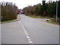
The road from Lower Race to Upper Race
Minor road heading south off the A472
Image: © Stuart Wilding
Taken: 11 Mar 2007
0.03 miles
2
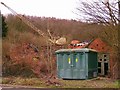
Scrap Yard, Lower Race
Though I'm not sure if it's just a dumping ground.
Image: © Stuart Wilding
Taken: 11 Mar 2007
0.08 miles
3
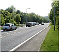
A472 approaches Lower Race and Upper Race junction, Pontypool
The car facing the camera has just joined the A472 from the road from Lower Race and Upper Race.
The black arrow on the sign on the right points the way to the two Races.
Image: © Jaggery
Taken: 25 May 2011
0.11 miles
4
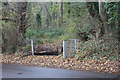
Footpath north from Crumlin Road
Little used public woodland footpath to Parkes Lane.
Image: © M J Roscoe
Taken: 16 Nov 2019
0.11 miles
5
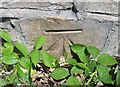
Ordnance Survey Cut Mark
This OS cut mark can be found on the wall of Wernside, Crumlin Road. It marks a point 159.188m above mean sea level.
Image: © Adrian Dust
Taken: 7 Jul 2019
0.12 miles
6
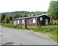
St John Ambulance building, Crumlin Bungalows, Pontypool
Located in a locked enclosure on the north side of a road named Crumlin Bungalows, in the Sowhill area of Pontypool.
Image: © Jaggery
Taken: 25 May 2011
0.14 miles
7
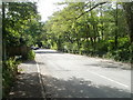
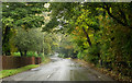
Semi-rural Crumlin Road, Pontypool
Although still within Pontypool, Crumlin Road here looks like a country road. It is sometimes referred to as Old Crumlin Road to distinguish it from the A472, which is used by almost all the traffic between Pontypool and Crumlin. The A472 is a few metres to the south (left) at this point.
Image: © Jaggery
Taken: 25 May 2011
0.17 miles
8
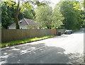
Fenced-in bungalow, Crumlin Road, Pontypool
There are only a few dwellings here and there along this section of Crumlin Road, in the western edge of Pontypool. Most of the traffic in this area uses the A472, at this point about 15 metres behind the bungalow.
Image: © Jaggery
Taken: 25 May 2011
0.17 miles
9
Crumlin Road heading west
Crumlin Road, west of Pontypool, runs east - west on the north side of the A472 and was probably, the original line of that road which connects Pontypool with Crumlin.
Image: © Trevor Littlewood
Taken: 14 Oct 2016
0.17 miles
10
Southern end of Twmpath Road, Sowhill, Pontypool
Twmpath Road climbs away from the corner of Crumlin Bungalows, heading for High Street, Tranch.
Image: © Jaggery
Taken: 25 May 2011
0.20 miles