IMAGES TAKEN NEAR TO
Shepherds Hill Caravan Site, PONTYPOOL, NP4 5UF
Introduction
This page details the photographs taken nearby to Shepherds Hill Caravan Site, NP4 5UF by members of the Geograph project.
The Geograph project started in 2005 with the aim of publishing, organising and preserving representative images for every square kilometre of Great Britain, Ireland and the Isle of Man.

There are currently over 7.5m images from over14,400 individuals and you can help contribute to the project by visiting https://www.geograph.org.uk
Image Map
Images are licensed for reuse under creativecommons.org/licenses/by-sa/2.0
Notes
- Clicking on the map will re-center to the selected point.
- The higher the marker number, the further away the image location is from the centre of the postcode.
Image Listing (30 Images Found)
Images are licensed for reuse under creativecommons.org/licenses/by-sa/2.0
Image
Details
Distance
1
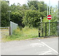
Track into woods, Upper Race, Pontypool
The track is near the Race AFC changing rooms. http://www.geograph.org.uk/photo/2452397
The No Entry sign is at the edge of a car park on the Coleg Gwent Pontypool Campus.
Image: © Jaggery
Taken: 9 Jun 2011
0.08 miles
2
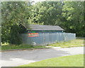
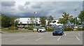
Race AFC changing rooms, Upper Race, Pontypool
Located at the western edge of the grounds of the Coleg Gwent Pontypool Campus.
Race AFC (Association Football Club), founded in 1905, play their homes games on a campus pitch. http://www.geograph.org.uk/photo/2452428
These changing rooms, within a fenced enclosure, contain three sections, each with its own entrance doorway and black-on-green title. The doorway on the left is for the home team, the one on the right is for the away team, with the referee's facilities in the middle.
Image: © Jaggery
Taken: 9 Jun 2011
0.08 miles
3
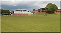
Pontypool campus buildings viewed across football pitch
The buildings and pitch http://www.geograph.org.uk/photo/2452428 are part of the Coleg Gwent Pontypool Campus.
Image: © Jaggery
Taken: 9 Jun 2011
0.11 miles
4
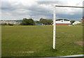
Football pitch, Upper Race, Pontypool
The pitch, on the western edge of the Coleg Gwent Pontypool Campus, is used for home games by Race AFC (Association Football Club). Their changing rooms are nearby. http://www.geograph.org.uk/photo/2452397
Image: © Jaggery
Taken: 9 Jun 2011
0.11 miles
5
Car park and SW side of Coleg Gwent Pontypool campus
Viewed from an unnamed side road connecting the car park with Blaendare Road, Upper Race.
Image: © Jaggery
Taken: 9 Jun 2011
0.13 miles
6
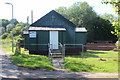
Race Methodist Church, Upper Race
Small chapel of corrugated iron on Blaendare Road. 'Sunday Service 4.00 pm'.
Image: © M J Roscoe
Taken: 8 Aug 2020
0.13 miles
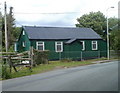
8
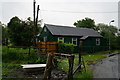
Centenary of Race Methodist Church, Pontypool
This view of the church on Blaendare Road, Upper Race, was taken in June 2011, one hundred years after the prefabricated building opened for worship here in June 1911. The project was paid for with money donated by local people.
http://www.geograph.org.uk/photo/2452353 to a side view.
There was a time, decades ago, when prefabricated corrugated-metal churches ("tin churches"), such as this one, were a common sight in many parts of the UK. Many have now been replaced by more modern buildings, but in Pontypool, two remain in use within about a kilometre of each other. The other one is St Matthew's Church, Pontymoile. http://www.geograph.org.uk/photo/2451844
Image: © Jaggery
Taken: 9 Jun 2011
0.13 miles
9
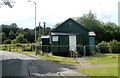
Side view of Race Methodist Church, Pontypool
The church was celebrating the centenary of its opening in June 1911 at the date of this photo.
http://www.geograph.org.uk/photo/2452335 to a front view.
Image: © Jaggery
Taken: 9 Jun 2011
0.13 miles
10
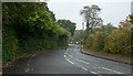
Minor road south-west of Cwmynyscoy
Cwmynyscoy is a village on the northern slopes of the moorland hill, Mynydd Twyn-glas; it's also close to Pontypool.
Image: © Trevor Littlewood
Taken: 14 Oct 2016
0.14 miles