IMAGES TAKEN NEAR TO
Cwmynyscoy Road, PONTYPOOL, NP4 5SL
Introduction
This page details the photographs taken nearby to Cwmynyscoy Road, NP4 5SL by members of the Geograph project.
The Geograph project started in 2005 with the aim of publishing, organising and preserving representative images for every square kilometre of Great Britain, Ireland and the Isle of Man.

There are currently over 7.5m images from over14,400 individuals and you can help contribute to the project by visiting https://www.geograph.org.uk
Image Map
Images are licensed for reuse under creativecommons.org/licenses/by-sa/2.0
Notes
- Clicking on the map will re-center to the selected point.
- The higher the marker number, the further away the image location is from the centre of the postcode.
Image Listing (50 Images Found)
Images are licensed for reuse under creativecommons.org/licenses/by-sa/2.0
Image
Details
Distance
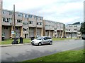
1
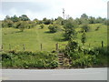
Steps up to a field, Cwmynyscoy Road, Pontypool
Viewed from the SW edge of flats in Viaduct Court.
Image: © Jaggery
Taken: 13 Jun 2011
0.03 miles
2
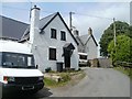
Cwm Farm, Pontypool
At the end of Cwm Farm Lane are Cwm Farm Cottage and, behind it, Cwm Farm House.
Behind the camera, the lane connects with Cwmynyscoy Road.
Image: © Jaggery
Taken: 13 Jun 2011
0.04 miles
3
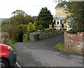
Prescoch Lane passes Pres-coch, Pontypool
On its descent from Penyrheol, Prescoch Lane passes a house named Pres-coch before entering the wooded area ahead.
Image: © Jaggery
Taken: 26 Oct 2011
0.09 miles
4
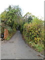
Northern end of Prescoch Lane, Pontymoile, Pontypool
Prescoch Lane climbs away from Cwmynyscoy Road. Ahead is the hamlet of Penyrheol, a little over a kilometre away.
Image: © Jaggery
Taken: 26 Oct 2011
0.10 miles
5
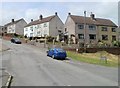
Hillside Drive houses, Pontypool
Houses in the Cwm Fields area of Pontypool, viewed from the corner of Cwm Farm Lane.
Image: © Jaggery
Taken: 13 Jun 2011
0.10 miles
6
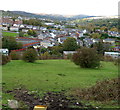
Cwm Fields area of Pontypool
Viewed from Prescoch Lane. The long line of houses in the middle of the view are on St Matthews Road, http://www.geograph.org.uk/photo/2451852 adjacent to the playing area of Pontymoile Primary School.
Image: © Jaggery
Taken: 26 Oct 2011
0.11 miles
7
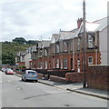
St Matthew's Road, Pontypool
Houses on the west side of the road.
Image: © Jaggery
Taken: 9 Jun 2011
0.11 miles
8
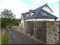
Modern house, Prescoch Lane, Pontypool
A view north along Prescoch Lane on its descent from Penyrheol to Cwmynyscoy Road.
Image: © Jaggery
Taken: 26 Oct 2011
0.12 miles
9
Viaduct Court flats, Pontypool
Located on the north side of Cwmynyscoy Road. The flats are named after the demolished Cwmynyscoy railway viaduct.
Image: © Jaggery
Taken: 13 Jun 2011
0.13 miles
10
Pontymoile O.A.P Club, Pontypool
Located in the O.A.P Hall at the NE end of Cwmynyscoy Road, near Cwmynyscoy Roundabout. http://www.geograph.org.uk/photo/1578870
Also known as the Pontymoile Senior Citizens' Club. Meetings are held on Mondays from 2pm to 4pm and on Tuesdays from 9.30am to noon. Cake decorating is Monday evenings from 6.30 to 8.30.
Image: © Jaggery
Taken: 13 Jun 2011
0.13 miles