IMAGES TAKEN NEAR TO
Greys Road, PONTYPOOL, NP4 5SH
Introduction
This page details the photographs taken nearby to Greys Road, NP4 5SH by members of the Geograph project.
The Geograph project started in 2005 with the aim of publishing, organising and preserving representative images for every square kilometre of Great Britain, Ireland and the Isle of Man.

There are currently over 7.5m images from over14,400 individuals and you can help contribute to the project by visiting https://www.geograph.org.uk
Image Map
Images are licensed for reuse under creativecommons.org/licenses/by-sa/2.0
Notes
- Clicking on the map will re-center to the selected point.
- The higher the marker number, the further away the image location is from the centre of the postcode.
Image Listing (39 Images Found)
Images are licensed for reuse under creativecommons.org/licenses/by-sa/2.0
Image
Details
Distance
1
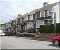
Farm Road houses, Pontypool
Viewed from the corner of Blaendare Road.
Image: © Jaggery
Taken: 9 Jun 2011
0.04 miles
2
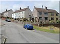
Hillside Drive houses, Pontypool
Houses in the Cwm Fields area of Pontypool, viewed from the corner of Cwm Farm Lane.
Image: © Jaggery
Taken: 13 Jun 2011
0.07 miles
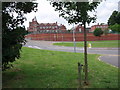
3
Southern side of West Monmouth School, Pontypool
Viewed across Blaendare Road. The school http://www.geograph.org.uk/photo/2451805 was Grade II listed in 1997.
Image: © Jaggery
Taken: 9 Jun 2011
0.10 miles
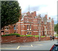
4
West Monmouth School Pontypool
West Monmouth School Pontypool Opened in 1898 Jones West Monmouth Grammar School for Boys was built used funds provided by the Worshipful Company of Haberdashers “West Mon” is now a comprehensive school for both sexes
Image: © gj
Taken: 23 Jun 2006
0.10 miles
5
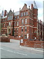
Entrance to West Monmouth School, Pontypool
The SE side of the Grade II listed school, http://www.geograph.org.uk/photo/2451805 viewed across Blaendare Road.
Image: © Jaggery
Taken: 9 Jun 2011
0.10 miles
6
Cwm Farm, Pontypool
At the end of Cwm Farm Lane are Cwm Farm Cottage and, behind it, Cwm Farm House.
Behind the camera, the lane connects with Cwmynyscoy Road.
Image: © Jaggery
Taken: 13 Jun 2011
0.13 miles
7
Just some of the food for the Valleys 100 walk
Image: © Ian S
Taken: 24 May 2014
0.14 miles
8
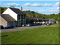
Wheatsheaf Inn and terrace of houses, Cwmynyscoy
Image: © Ruth Sharville
Taken: 11 May 2012
0.14 miles
9
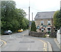
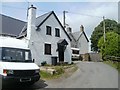
The Unicorn Inn, Cwmynyscoy, Pontypool
Located at a kink in the course of Cwmynyscoy Road. With many pubs elsewhere closed down, it is surprising that there are two open pubs only about 140 metres apart in the small community of Cwmynyscoy. The other one is the Wheatsheaf Inn. http://www.geograph.org.uk/photo/2461888
There are two Unicorn pubs in Pontypool. The other one is on Albion Road. http://www.geograph.org.uk/photo/2437469
Image: © Jaggery
Taken: 13 Jun 2011
0.15 miles
10
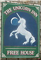
Pub sign, The Unicorn Inn, Cwmynyscoy, Pontypool
This sign is fixed to the wall on the east side of the pub http://www.geograph.org.uk/photo/2461941 in the small community of Cwmynyscoy, Pontypool.
Image: © Jaggery
Taken: 13 Jun 2011
0.15 miles