IMAGES TAKEN NEAR TO
Blaendare Road, PONTYPOOL, NP4 5RY
Introduction
This page details the photographs taken nearby to Blaendare Road, NP4 5RY by members of the Geograph project.
The Geograph project started in 2005 with the aim of publishing, organising and preserving representative images for every square kilometre of Great Britain, Ireland and the Isle of Man.

There are currently over 7.5m images from over14,400 individuals and you can help contribute to the project by visiting https://www.geograph.org.uk
Image Map
Images are licensed for reuse under creativecommons.org/licenses/by-sa/2.0
Notes
- Clicking on the map will re-center to the selected point.
- The higher the marker number, the further away the image location is from the centre of the postcode.
Image Listing (65 Images Found)
Images are licensed for reuse under creativecommons.org/licenses/by-sa/2.0
Image
Details
Distance
1
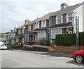
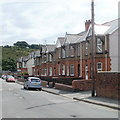
Farm Road houses, Pontypool
Viewed from the corner of Blaendare Road.
Image: © Jaggery
Taken: 9 Jun 2011
0.04 miles
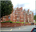
2
West Monmouth School Pontypool
West Monmouth School Pontypool Opened in 1898 Jones West Monmouth Grammar School for Boys was built used funds provided by the Worshipful Company of Haberdashers “West Mon” is now a comprehensive school for both sexes
Image: © gj
Taken: 23 Jun 2006
0.06 miles
3
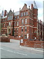
Entrance to West Monmouth School, Pontypool
The SE side of the Grade II listed school, http://www.geograph.org.uk/photo/2451805 viewed across Blaendare Road.
Image: © Jaggery
Taken: 9 Jun 2011
0.06 miles
4
Southern side of West Monmouth School, Pontypool
Viewed across Blaendare Road. The school http://www.geograph.org.uk/photo/2451805 was Grade II listed in 1997.
Image: © Jaggery
Taken: 9 Jun 2011
0.06 miles
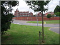
5
Just some of the food for the Valleys 100 walk
Image: © Ian S
Taken: 24 May 2014
0.08 miles
6
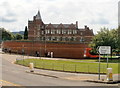
Eastern side of West Monmouth School, Pontypool
Viewed from Victoria Road. The school, on the north side of Blaendare Road, opened in 1898 as Jones’ West Monmouth School. With funds provided by the Haberdashers' Company, it was built as a boys' private day and boarding grammar school. It became a local authority grammar school in 1957 and a mixed comprehensive in 1982.
Surprisingly for such a fine building, it was not until 1997 that it was Grade II listed.
Image: © Jaggery
Taken: 9 Jun 2011
0.11 miles
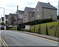
7
Hillside Drive houses, Pontypool
Houses in the Cwm Fields area of Pontypool, viewed from the corner of Cwm Farm Lane.
Image: © Jaggery
Taken: 13 Jun 2011
0.13 miles
8

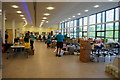
Getting ready for the start
Nearly 500 walkers and runners will start this years LDWA Valleys 100 from Pontypool. Because of the weather over 200 will not finish the event.
Image: © Ian S
Taken: 24 May 2014
0.13 miles
9
St Matthew's Road, Pontypool
Houses on the west side of the road.
Image: © Jaggery
Taken: 9 Jun 2011
0.17 miles
10
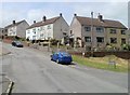
Blaendare Road houses, Pontypool
Houses on the north side of the road, about 80 metres SW of the junction with Hillside Drive.
Image: © Jaggery
Taken: 9 Jun 2011
0.17 miles