1
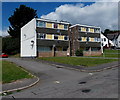
Wern School Close, Sebastopol, Pontypool
Viewed across School Crescent.
Image: © Jaggery
Taken: 9 Aug 2014
0.03 miles
2
Wern School Close bungalows, Sebastopol, Pontypool
Wern School Close is on the west side of School Crescent.
Image: © Jaggery
Taken: 9 Aug 2014
0.03 miles
3
3-storey block of flats in School Crescent, Sebastopol, Pontypool
At the northern end of School Crescent, near the Wern Road junction.
Image: © Jaggery
Taken: 9 Aug 2014
0.04 miles
4
Penry Gospel Hall, Sebastopol, Pontypool
Viewed across South Street. The building was previously Penry Congregational Church.
The year 1895 is engraved on a tablet on the wall above the round window.
Image: © Jaggery
Taken: 9 Aug 2014
0.05 miles
5
Corner of Alma Place and South Street, Sebastopol, Pontypool
Salon Eighteen at 18 South Street is on the left side of the white door.
Image: © Jaggery
Taken: 9 Aug 2014
0.05 miles
6
Patterned brick houses in Alma Place, Sebastopol, Pontypool
Looking towards the South Street junction.
Image: © Jaggery
Taken: 9 Aug 2014
0.05 miles
7
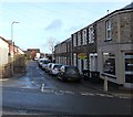
Wern Road, Sebastopol, Pontypool
Looking WSW past the School Crescent junction. St Oswald's Church http://www.geograph.org.uk/photo/4111192 is in the middle.
Image: © Jaggery
Taken: 9 Aug 2014
0.06 miles
8
Wern Road, Sebastopol, Pontypool
Viewed across South Street. Sweeneys http://www.geograph.org.uk/photo/4321838 is on the right.
Image: © Jaggery
Taken: 24 Jan 2015
0.06 miles
9
Sherbourne Court, Sebastopol, Pontypool
Viewed across Sherbourne Road. Built in 1970, Sherbourne Court is retirement/sheltered housing owned by Bron Afon Community Housing. New residents must be at least 60 years old.
Image: © Jaggery
Taken: 9 Aug 2014
0.06 miles
10
Sherbourne Road, Sebastopol, Pontypool
Viewed from South Street.
Image: © Jaggery
Taken: 21 Oct 2009
0.06 miles


