IMAGES TAKEN NEAR TO
Mountain Lane, PONTYPOOL, NP4 5LW
Introduction
This page details the photographs taken nearby to Mountain Lane, NP4 5LW by members of the Geograph project.
The Geograph project started in 2005 with the aim of publishing, organising and preserving representative images for every square kilometre of Great Britain, Ireland and the Isle of Man.

There are currently over 7.5m images from over14,400 individuals and you can help contribute to the project by visiting https://www.geograph.org.uk
Image Map
Images are licensed for reuse under creativecommons.org/licenses/by-sa/2.0
Notes
- Clicking on the map will re-center to the selected point.
- The higher the marker number, the further away the image location is from the centre of the postcode.
Image Listing (57 Images Found)
Images are licensed for reuse under creativecommons.org/licenses/by-sa/2.0
Image
Details
Distance
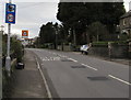
1
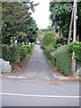
Mountain Lane, Griffithstown, Pontypool
Viewed from Sunnybank Road.
Image: © Jaggery
Taken: 21 Oct 2009
0.04 miles
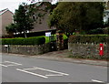
2
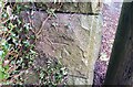
Ordnance Survey Cut Mark
This OS cut mark can be found on the wall of No67 Sunnybank Road. It marks a point 147.636m above mean sea level.
Image: © Adrian Dust
Taken: 16 Feb 2021
0.06 miles
3
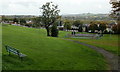
Recreation Ground, Sunnybank Road, Griffithstown
The view across a recreation area from its southwest corner on the eastern side of Sunnybank Road.
Image: © Jaggery
Taken: 21 Oct 2009
0.06 miles
4
St Mary's Close, Griffithstown, Pontypool
Viewed across St Mary Street. Griffithstown Allotments http://www.geograph.org.uk/photo/3416633 are on the left.
Image: © Jaggery
Taken: 18 Apr 2013
0.07 miles
5
Speed camera sign, Stafford Road, Griffithstown, Pontypool
Behind the speed camera sign, a Playground sign is on the approach to a large recreation area.
Image: © Jaggery
Taken: 27 Jan 2015
0.07 miles
6
King George V postbox, Sunnybank Road, Griffithstown, Pontypool
The wall box faces a recreation ground. http://www.geograph.org.uk/photo/4329144
Image: © Jaggery
Taken: 27 Jan 2015
0.07 miles
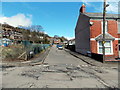
7
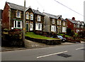
Sunnybank Road houses in Griffithstown, Pontypool
On the west side of the road, between Mountain Lane and Hillside Road.
Image: © Jaggery
Taken: 27 Jan 2015
0.08 miles
9
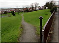
Recreation ground entrance path, Griffithstown, Pontypool
From Sunnybank Road.
Image: © Jaggery
Taken: 27 Jan 2015
0.09 miles
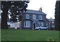
10
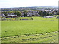
Griffithstown View
The Recreation Ground off Sunnybank Road.
Image: © Gordon Griffiths
Taken: 17 Sep 2011
0.09 miles