IMAGES TAKEN NEAR TO
Open Hearth Close, PONTYPOOL, NP4 5LU
Introduction
This page details the photographs taken nearby to Open Hearth Close, NP4 5LU by members of the Geograph project.
The Geograph project started in 2005 with the aim of publishing, organising and preserving representative images for every square kilometre of Great Britain, Ireland and the Isle of Man.

There are currently over 7.5m images from over14,400 individuals and you can help contribute to the project by visiting https://www.geograph.org.uk
Image Map
Images are licensed for reuse under creativecommons.org/licenses/by-sa/2.0
Notes
- Clicking on the map will re-center to the selected point.
- The higher the marker number, the further away the image location is from the centre of the postcode.
Image Listing (149 Images Found)
Images are licensed for reuse under creativecommons.org/licenses/by-sa/2.0
Image
Details
Distance
1
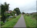
Jogger on the Mon & Brec canal towpath
Looking north.
Image: © Christine Johnstone
Taken: 15 Sep 2013
0.04 miles
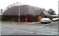
2
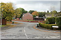
Open Hearth Close, Griffithstown
Viewed from Station Road.
Image: © Jaggery
Taken: 21 Oct 2009
0.04 miles
3
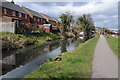
Houses overlooking the Monmouthshire and Brecon Canal
Houses overlooking the Monmouthshire and Brecon Canal near Griffithstown.
Image: © Philip Halling
Taken: 12 Apr 2013
0.04 miles
4
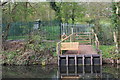
Bench by Monmouthshire & Brecon Canal
New wooden bench on opposite bank to tow path and milemarker Image There are school grounds behind the bench.
Image: © M J Roscoe
Taken: 12 Apr 2019
0.06 miles
5
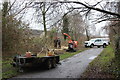
Tree thinning NCR 492, Griffithstown
Torfaen Council are felling and chipping some trees on the eastern boundary of National Cycle Route 492 which here is on a former railway track bed.
Image: © M J Roscoe
Taken: 29 Jan 2019
0.06 miles
6
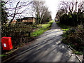
Footpath and cycleway in Griffithstown, Pontypool
Looking south past a dog waste box. The route here is between Station Road and houses in Churchwood.
Maps show that this flat straight route used to be a railway.
Image: © Jaggery
Taken: 24 Jan 2015
0.06 miles
7
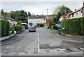
Martindale Road, Griffithstown
Viewed from Station Road.
Image: © Jaggery
Taken: 21 Oct 2009
0.07 miles
8
Army Cadet Force (ACF), Griffithstown, Pontypool
Located within a fenced-off area on Canal Close, this is the building, officially termed a hut, of the Griffithstown Detachment of the ACF.
The role of the ACF is to inspire young people to achieve success with a spirit of service to the Queen, country and their local community, and to develop the qualities of good citizenship, responsibility and leadership.
Image: © Jaggery
Taken: 21 Jan 2011
0.07 miles
9

Disused canal south of bridge 49, Griffithstown, Pontypool
The view south, from bridge 49, http://www.geograph.org.uk/photo/2246986 along the former Monmouthshire & Brecon Canal.
Image: © Jaggery
Taken: 21 Jan 2011
0.07 miles
10
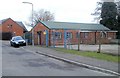
Panteg Health Centre, Pontypool
Located on the corner of Kemys Street and Canal Close. The centre opened in 1990.
Image: © Jaggery
Taken: 21 Jan 2011
0.07 miles