IMAGES TAKEN NEAR TO
School View, PONTYPOOL, NP4 5LB
Introduction
This page details the photographs taken nearby to School View, NP4 5LB by members of the Geograph project.
The Geograph project started in 2005 with the aim of publishing, organising and preserving representative images for every square kilometre of Great Britain, Ireland and the Isle of Man.

There are currently over 7.5m images from over14,400 individuals and you can help contribute to the project by visiting https://www.geograph.org.uk
Image Map
Images are licensed for reuse under creativecommons.org/licenses/by-sa/2.0
Notes
- Clicking on the map will re-center to the selected point.
- The higher the marker number, the further away the image location is from the centre of the postcode.
Image Listing (128 Images Found)
Images are licensed for reuse under creativecommons.org/licenses/by-sa/2.0
Image
Details
Distance
1
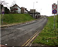
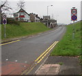
Entrance slip road to the A472, Pontypool
From Rockhill Road, this is one of the motorway-style slip roads
to and from the A472, which here follows the route of a dismantled railway.
Image: © Jaggery
Taken: 27 Jan 2015
0.05 miles
2
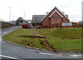
Rear view of Pontymoile Undenominational Christian Mission, Pontypool
The view from the east of a church located between Rockhill Road and an exit slip road from the A472. http://www.geograph.org.uk/photo/2250731 to the view from the west.
Image: © Jaggery
Taken: 26 Jan 2011
0.06 miles
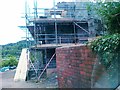
3
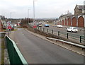
Slip road from A472 to Rockhill Road, Pontypool
The A472 here follows the course of a dismantled railway. There is a long row of bricked-up arches http://www.geograph.org.uk/photo/2250682 on the far side of the road.
Image: © Jaggery
Taken: 26 Jan 2011
0.06 miles
4
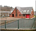
Front view of Pontymoile Undenominational Christian Mission, Pontypool
Viewed from the west. http://www.geograph.org.uk/photo/2250514 to the view from the east.
Image: © Jaggery
Taken: 26 Jan 2011
0.06 miles
5
Entry slip road to the A472, Pontypool
From Rockhill Road. The speed limit increases to 50mph. A nearby sign https://www.geograph.org.uk/photo/5758412 shows this way for Newbridge.
Image: © Jaggery
Taken: 11 Apr 2018
0.06 miles
7
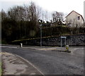
Left for Griffithstown, Pontypool
The direction sign is on the SW side of Cwmynyscoy Roundabout. http://www.geograph.org.uk/photo/1578870
Image: © Jaggery
Taken: 27 Jan 2015
0.07 miles
8
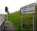
Bilingual direction sign, Pontypool
The sign alongside an A472 entry slip road shows that Newbridge is Trecelyn in Welsh and Pontypool is Pontypŵl.
Image: © Jaggery
Taken: 11 Apr 2018
0.08 miles
9
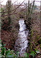
White water over a weir, Pontypool
Between Maesderwen Road and Rockhill Road, an unnamed small tributary of the Afon Lwyd flows over a weir.
Image: © Jaggery
Taken: 27 Jan 2015
0.08 miles
10
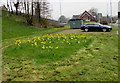
Rectangle of daffodils alongside Rockhill Road, Pontypool
On April 11th 2018 daffodils are in an unmown rectangle surrounded by mown grass.
Image: © Jaggery
Taken: 11 Apr 2018
0.08 miles