IMAGES TAKEN NEAR TO
Park View, PONTYPOOL, NP4 5JT
Introduction
This page details the photographs taken nearby to Park View, NP4 5JT by members of the Geograph project.
The Geograph project started in 2005 with the aim of publishing, organising and preserving representative images for every square kilometre of Great Britain, Ireland and the Isle of Man.

There are currently over 7.5m images from over14,400 individuals and you can help contribute to the project by visiting https://www.geograph.org.uk
Image Map
Images are licensed for reuse under creativecommons.org/licenses/by-sa/2.0
Notes
- Clicking on the map will re-center to the selected point.
- The higher the marker number, the further away the image location is from the centre of the postcode.
Image Listing (236 Images Found)
Images are licensed for reuse under creativecommons.org/licenses/by-sa/2.0
Image
Details
Distance
1
Slip road from A472, Pontymoel
The slip road from the A472 http://www.geograph.org.uk/photo/2250682 exits into Rockhill Road. On the right is the edge of Pontymoile Undenominational Christian Mission. http://www.geograph.org.uk/photo/2250514
Image: © Jaggery
Taken: 26 Jan 2011
0.03 miles
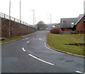
2
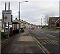
Slip road from A472 to Rockhill Road, Pontypool
Viewed from a footbridge. http://www.geograph.org.uk/photo/2451682 The footpath on the left runs alongside the slip road towards Rockhill Road. On the right are Park View Terrace houses.
Image: © Jaggery
Taken: 9 Jun 2011
0.03 miles
3
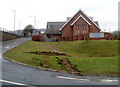
Rear view of Pontymoile Undenominational Christian Mission, Pontypool
The view from the east of a church located between Rockhill Road and an exit slip road from the A472. http://www.geograph.org.uk/photo/2250731 to the view from the west.
Image: © Jaggery
Taken: 26 Jan 2011
0.04 miles
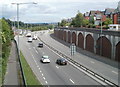
4
Slip road from A472 to Rockhill Road, Pontypool
The A472 here follows the course of a dismantled railway. There is a long row of bricked-up arches http://www.geograph.org.uk/photo/2250682 on the far side of the road.
Image: © Jaggery
Taken: 26 Jan 2011
0.04 miles
5
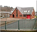
Front view of Pontymoile Undenominational Christian Mission, Pontypool
Viewed from the west. http://www.geograph.org.uk/photo/2250514 to the view from the east.
Image: © Jaggery
Taken: 26 Jan 2011
0.04 miles
6
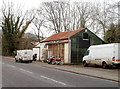
Ray Cowles Motorcycles, Pontypool
Motorbike shop located in characterful premises on Rockhill Road.
Image: © Jaggery
Taken: 26 Jan 2011
0.06 miles
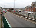
7
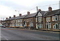
Rockhill Road, Pontypool
A long row of houses, built c1900, on the north side of Rockhill Road. There are no houses on the opposite side of the road, part of which is occupied by a church. http://www.geograph.org.uk/photo/2250514
Image: © Jaggery
Taken: 26 Jan 2011
0.06 miles
8
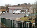
Moyse Plumbing Supplies, Pontypool
Located at the western end of Rockhill Road, next to a long row of houses. http://www.geograph.org.uk/photo/2250714
Image: © Jaggery
Taken: 26 Jan 2011
0.06 miles
9
All traffic straight ahead on Clarence Road, Pontypool
No right turns here.
Image: © Jaggery
Taken: 27 Jan 2015
0.07 miles
10
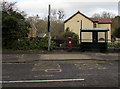
King George V postbox, Pontypool
Located near a bus shelter on the north side of Clarence Road.
The GR on the box is short for Georgius Rex, Latin for King George,
in this case King George V who reigned from May 1910-January 1936.
Image: © Jaggery
Taken: 27 Jan 2015
0.07 miles