IMAGES TAKEN NEAR TO
Station Road, PONTYPOOL, NP4 5JL
Introduction
This page details the photographs taken nearby to Station Road, NP4 5JL by members of the Geograph project.
The Geograph project started in 2005 with the aim of publishing, organising and preserving representative images for every square kilometre of Great Britain, Ireland and the Isle of Man.

There are currently over 7.5m images from over14,400 individuals and you can help contribute to the project by visiting https://www.geograph.org.uk
Image Map
Images are licensed for reuse under creativecommons.org/licenses/by-sa/2.0
Notes
- Clicking on the map will re-center to the selected point.
- The higher the marker number, the further away the image location is from the centre of the postcode.
Image Listing (150 Images Found)
Images are licensed for reuse under creativecommons.org/licenses/by-sa/2.0
Image
Details
Distance
1
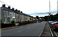
Long row of houses in Station Road, Griffithstown, Pontypool
The houses are opposite a long narrow car park. http://www.geograph.org.uk/photo/4115154
Image: © Jaggery
Taken: 9 Aug 2014
0.00 miles
2
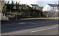
Fenced-off site in Station Road, Griffithstown, Pontypool
The site of the demolished Masons Arms http://www.geograph.org.uk/photo/1594674 viewed in January 2015.
Image: © Jaggery
Taken: 24 Jan 2015
0.02 miles
3
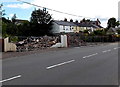
Fenced-off site of the Masons Arms pub in Griffithstown, Pontypool
Viewed across Station Road on Saturday August 9th 2014 when fencing surrounds building rubble that used to be the Mason Arms pub, seen here http://www.geograph.org.uk/photo/1594674 in October 2009.
The building had been standing until five days earlier, when a fire broke out. When fire crews arrived, there were flames on both floors. The fire had also broken through the roof and damaged the adjoining building, a former betting shop. Station Road was closed for several hours, with diversions in place.
The South Wales Argus reported that South Wales Fire and Rescue Service had said that there were no people injured, but were not yet able to say how the fire started.
Image: © Jaggery
Taken: 9 Aug 2014
0.02 miles
4
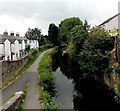
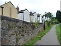
Canal, path and houses, Pontypool
Viewed from Coedygric Road on Monmouthshire and Brecon Canal bridge number 50. http://www.geograph.org.uk/photo/94958
Image: © Jaggery
Taken: 9 Aug 2014
0.02 miles
5
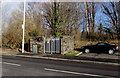
Station Road electricity substation in Griffithstown, Pontypool
The Western Power Distribution electricity substation identifier is
STATION RD. GRIFFITHSTOWN S/S No. 531476.
Image: © Jaggery
Taken: 24 Jan 2015
0.02 miles
6
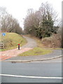
National Cycle Network route 492, Pontypool
Viewed across New Road, a cycle route uses the track bed of a dismantled railway.
Image: © Jaggery
Taken: 21 Jan 2011
0.03 miles
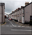
7
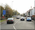
Station Road, Griffithstown
The view south along Station Road from Coedygric Road.
Image: © Jaggery
Taken: 21 Oct 2009
0.04 miles
8
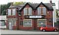
Former Masons Arms, Station Road, Griffithstown
Boarded up and for sale in October 2009.
Image: © Jaggery
Taken: 21 Oct 2009
0.04 miles
9
Gable ends of houses in Station Road, Griffithstown
Seen from the Mon & Brec canal towpath.
Image: © Christine Johnstone
Taken: 15 Sep 2013
0.04 miles
10
Northern end of Bridge Street, Griffithstown, Pontypool
Looking south across Coedygric Road.
Image: © Jaggery
Taken: 9 Aug 2014
0.04 miles