IMAGES TAKEN NEAR TO
Windsor Road, PONTYPOOL, NP4 5HY
Introduction
This page details the photographs taken nearby to Windsor Road, NP4 5HY by members of the Geograph project.
The Geograph project started in 2005 with the aim of publishing, organising and preserving representative images for every square kilometre of Great Britain, Ireland and the Isle of Man.

There are currently over 7.5m images from over14,400 individuals and you can help contribute to the project by visiting https://www.geograph.org.uk
Image Map
Images are licensed for reuse under creativecommons.org/licenses/by-sa/2.0
Notes
- Clicking on the map will re-center to the selected point.
- The higher the marker number, the further away the image location is from the centre of the postcode.
Image Listing (158 Images Found)
Images are licensed for reuse under creativecommons.org/licenses/by-sa/2.0
Image
Details
Distance
1
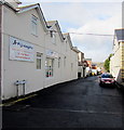
Queen Street, Griffithstown, Pontypool
Looking north from Hill Street past Fighting Fit http://www.geograph.org.uk/photo/4323831 on the left.
Image: © Jaggery
Taken: 24 Jan 2015
0.01 miles
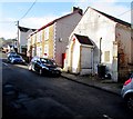
2
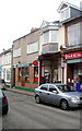
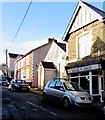
Griffithstown Post Office, Pontypool
52 Windsor Road, Griffithstown. The adjacent shops are
Truly Tasteful, cake shop and sandwich bar.
R&R Retail Ltd, newsagent, tobacconist, confectionery, toys, stationery and National Lottery outlet.
Image: © Jaggery
Taken: 21 Jan 2011
0.01 miles
3
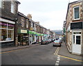
Windsor Road, Griffithstown, Pontypool
The view north from the crossroads with Hill Street and Oxford Street.
Windsor Road is the main shopping area of Griffithstown, and contains the post office. http://www.geograph.org.uk/photo/2246115
Image: © Jaggery
Taken: 21 Jan 2011
0.01 miles
4
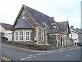
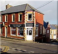
The Oily Rag (GWRSA), Griffithstown, Pontypool
The Oily Rag is the colloquial name for the GWRSA club on the corner of Hill Street and Commercial Street, Griffithstown. The club was formerly for employees of the Great Western Railway, which became part of British Railways in 1948.
The stone inscription above the double entrance arches is Mechanics Institute.
Image: © Jaggery
Taken: 21 Jan 2011
0.01 miles
5
Fighting Fit in Griffithstown, Pontypool
Fitness and fat loss training specialists on the corner of Queen Street and Hill Street.
Image: © Jaggery
Taken: 24 Jan 2015
0.02 miles
6
Bodyworks, Griffithstown, Pontypool
Tanning and beauty studio on the corner of Windsor Road and Hill Street.
Image: © Jaggery
Taken: 24 Jan 2015
0.03 miles
7
Eagle Balti, Griffithstown, Pontypool
Indian cuisine takeaway at 2A Hill Street.
Image: © Jaggery
Taken: 24 Jan 2015
0.04 miles
8
Oily Rag sold at auction, Griffithstown, Pontypool
In January 2015, there is a Paul Fosh Auctions SOLD board on the Oily Rag, the colloquial name for the GWRSA club on the corner of Hill Street and Commercial Street, Griffithstown. The club was formerly for employees of the Great Western Railway, which became part of British Railways in 1948. The stone inscription above the double entrance arches is Mechanics Institute.
Image: © Jaggery
Taken: 24 Jan 2015
0.04 miles
9
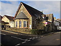
Former place of worship in Hill Street, Griffithstown, Pontypool
In January 2015, the front door and window are boarded up.
There is no name sign to show the denomination of this former church or chapel.
Image: © Jaggery
Taken: 24 Jan 2015
0.05 miles
10
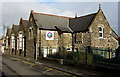
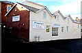
Ysgol Panteg, Griffithstown, Pontypool
Viewed across Oxford Street. Ysgol Panteg is a Welsh-medium infants school (all lessons are conducted through the medium of the Welsh language). The school's website states that Ysgol Panteg opened its doors for the first time in September 2010. The building was shared with Griffithstown Infant School for a term and a half.
The school started with 36 children. There are currently (January 2015) 177 pupils, in one of five year groups – Meithrin (Nursery), Derbyn (Reception), Blwyddyn 1 (Year 1), Blwyddyn 2 (Year 2) and Blwyddyn 3 (Year 3).
Image: © Jaggery
Taken: 24 Jan 2015
0.05 miles