IMAGES TAKEN NEAR TO
High Street, PONTYPOOL, NP4 5HU
Introduction
This page details the photographs taken nearby to High Street, NP4 5HU by members of the Geograph project.
The Geograph project started in 2005 with the aim of publishing, organising and preserving representative images for every square kilometre of Great Britain, Ireland and the Isle of Man.

There are currently over 7.5m images from over14,400 individuals and you can help contribute to the project by visiting https://www.geograph.org.uk
Image Map
Images are licensed for reuse under creativecommons.org/licenses/by-sa/2.0
Notes
- Clicking on the map will re-center to the selected point.
- The higher the marker number, the further away the image location is from the centre of the postcode.
Image Listing (164 Images Found)
Images are licensed for reuse under creativecommons.org/licenses/by-sa/2.0
Image
Details
Distance
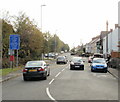
1
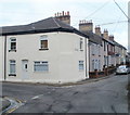
Corner of High Street and Bridge Street, Griffithstown, Pontypool
Viewed from the northern edge of Commercial Street. Ahead for Bridge Street, left for High Street.
Image: © Jaggery
Taken: 21 Jan 2011
0.02 miles
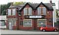
2
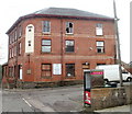
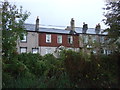
Former Hanbury Hotel, Griffithstown, Pontypool
Currently derelict, this large building on the corner of High Street and Windsor Road was formerly the Hanbury Hotel. Signs on the building announce
"17 x 1,2 & 3 Bedroom Architect Designed Apartments Commencing Summer 2010"
There was no external sign of activity when this view was taken in January 2011.
Image: © Jaggery
Taken: 21 Jan 2011
0.04 miles
3
Clifton Square, Griffithstown, Pontypool
Clifton Square is a small group of houses at the northern end of Queen Street, viewed from the edge of Commercial Street.
Image: © Jaggery
Taken: 21 Jan 2011
0.04 miles
4
Junction of Bridge Street, High Street and Commercial Street, Griffithstown, Pontypool
House on the corner of High Street and Commercial Street, viewed from Bridge Street.
http://www.geograph.org.uk/photo/2246540 to the view in the opposite direction.
Image: © Jaggery
Taken: 21 Jan 2011
0.04 miles
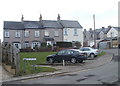
5
Broad Street, Griffithstown, Pontypool
Looking south from the Coedygric Road end.
Image: © Jaggery
Taken: 9 Aug 2014
0.04 miles
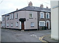
6
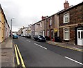
North along Commercial Street, Griffithstown, Pontypool
Despite its name, Commercial Street is mainly residential.
Image: © Jaggery
Taken: 24 Jan 2015
0.05 miles
7
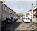
Houses on Bridge Street, Griffithstown
View from the Monmouthshire and Brecon Canal.
Image: © JThomas
Taken: 18 Oct 2019
0.05 miles
8
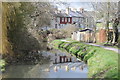
Houses reflected in the Monmouthshire and Brecon Canal
Houses reflected in the Monmouthshire and Brecon Canal near Griffithstown.
Image: © Philip Halling
Taken: 12 Apr 2013
0.06 miles
9
Station Road, Griffithstown
The view south along Station Road from Coedygric Road.
Image: © Jaggery
Taken: 21 Oct 2009
0.07 miles
10
Former Masons Arms, Station Road, Griffithstown
Boarded up and for sale in October 2009.
Image: © Jaggery
Taken: 21 Oct 2009
0.07 miles