IMAGES TAKEN NEAR TO
Coed Y Gric Road, PONTYPOOL, NP4 5HE
Introduction
This page details the photographs taken nearby to Coed Y Gric Road, NP4 5HE by members of the Geograph project.
The Geograph project started in 2005 with the aim of publishing, organising and preserving representative images for every square kilometre of Great Britain, Ireland and the Isle of Man.

There are currently over 7.5m images from over14,400 individuals and you can help contribute to the project by visiting https://www.geograph.org.uk
Image Map
Images are licensed for reuse under creativecommons.org/licenses/by-sa/2.0
Notes
- Clicking on the map will re-center to the selected point.
- The higher the marker number, the further away the image location is from the centre of the postcode.
Image Listing (113 Images Found)
Images are licensed for reuse under creativecommons.org/licenses/by-sa/2.0
Image
Details
Distance
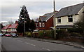
1
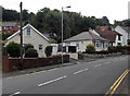
Coedygric Road houses in Griffithstown, Pontypool
Viewed from opposite the Picton Street junction. http://www.geograph.org.uk/photo/4114147
Image: © Jaggery
Taken: 9 Aug 2014
0.01 miles
2
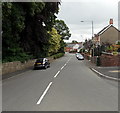
Coedygric Road, Griffithstown, Pontypool
Looking SE from Stafford Road.
Image: © Jaggery
Taken: 9 Aug 2014
0.01 miles
3
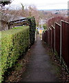
Between hedge and fence, Griffithstown, Pontypool
A footpath descends from Stafford Road to Coedygric Road.
Image: © Jaggery
Taken: 27 Jan 2015
0.02 miles
4
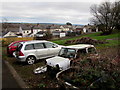
Two cars and two ex-cars in Griffithstown, Pontypool
Viewed in midwinter. No doubt the brambles will cover the remains of the car on the right next summer.
Image: © Jaggery
Taken: 27 Jan 2015
0.02 miles
5
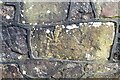
Ordnance Survey Cut Mark
This inverted OS cut mark can be found on the wall of the Hospital, Coedygric Road. It marks a point 124.733m above mean sea level.
Image: © Adrian Dust
Taken: 16 Feb 2021
0.03 miles
6
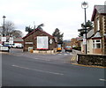
Entrance to County Hospital, Pontypool
Viewed across Coedygric Road from near the corner of Broad Street, Griffithstown.
Image: © Jaggery
Taken: 21 Jan 2011
0.03 miles
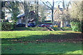
7
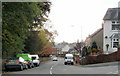
Coed-y-Gric Road, Griffithstown, Pontypool
Viewed from Stafford Road. The trees on the left are on the southern edge of County Hospital.
Image: © Jaggery
Taken: 21 Oct 2009
0.04 miles
8
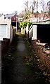
Short cut from Coedygric Road to Stafford Road, Griffithstown, Pontypool
A 90 metre long footpath connects the two streets.
Image: © Jaggery
Taken: 24 Jan 2015
0.04 miles
9
Cardiac Rehabilitation Unit, County Hospital, Griffithstown
The unit (old bell tower just visible) is in a former school on the edge of the hospital grounds.
Image: © M J Roscoe
Taken: 18 Dec 2017
0.04 miles
10
Housing variety in Griffithstown, Pontypool
Houses on the east side of Stafford Road.
Image: © Jaggery
Taken: 27 Jan 2015
0.04 miles