IMAGES TAKEN NEAR TO
Picton Street, PONTYPOOL, NP4 5HB
Introduction
This page details the photographs taken nearby to Picton Street, NP4 5HB by members of the Geograph project.
The Geograph project started in 2005 with the aim of publishing, organising and preserving representative images for every square kilometre of Great Britain, Ireland and the Isle of Man.

There are currently over 7.5m images from over14,400 individuals and you can help contribute to the project by visiting https://www.geograph.org.uk
Image Map
Images are licensed for reuse under creativecommons.org/licenses/by-sa/2.0
Notes
- Clicking on the map will re-center to the selected point.
- The higher the marker number, the further away the image location is from the centre of the postcode.
Image Listing (139 Images Found)
Images are licensed for reuse under creativecommons.org/licenses/by-sa/2.0
Image
Details
Distance
1
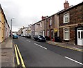
Broad Street, Griffithstown, Pontypool
Looking south from the Coedygric Road end.
Image: © Jaggery
Taken: 9 Aug 2014
0.04 miles
2
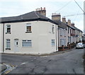
Corner of High Street and Bridge Street, Griffithstown, Pontypool
Viewed from the northern edge of Commercial Street. Ahead for Bridge Street, left for High Street.
Image: © Jaggery
Taken: 21 Jan 2011
0.04 miles
3
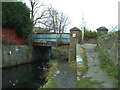
Bridge 50 (Union Bridge) Monmouth and Brecon Canal
This bridge is where the Griffithstown to New Inn road crosses the canal and is believed to be named after a long since demolished workhouse.
Image: © nantcoly
Taken: 24 Dec 2005
0.06 miles
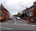
4
Exit from County Hospital, Pontypool
Viewed from Bridge Street. The road exits from the hospital into Coedygric Road.
Image: © Jaggery
Taken: 21 Jan 2011
0.06 miles
5
Northern section of Bridge Street, Griffithstown, Pontypool
Looking towards the junction with Coedygric Road. In the background is the SE edge of County Hospital. http://www.geograph.org.uk/photo/2246096
Image: © Jaggery
Taken: 21 Jan 2011
0.06 miles
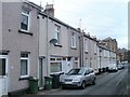
6
Picton Street, Griffithstown, Pontypool
Viewed across Coedygric Road looking south towards High Street.
Image: © Jaggery
Taken: 9 Aug 2014
0.07 miles
7
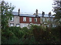
Houses on Bridge Street, Griffithstown
View from the Monmouthshire and Brecon Canal.
Image: © JThomas
Taken: 18 Oct 2019
0.08 miles
8
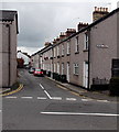
Northern end of Bridge Street, Griffithstown, Pontypool
Looking south across Coedygric Road.
Image: © Jaggery
Taken: 9 Aug 2014
0.08 miles
9
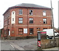
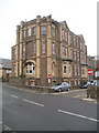
Former Hanbury Hotel, Griffithstown, Pontypool
Currently derelict, this large building on the corner of High Street and Windsor Road was formerly the Hanbury Hotel. Signs on the building announce
"17 x 1,2 & 3 Bedroom Architect Designed Apartments Commencing Summer 2010"
There was no external sign of activity when this view was taken in January 2011.
Image: © Jaggery
Taken: 21 Jan 2011
0.09 miles
10
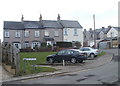
Clifton Square, Griffithstown, Pontypool
Clifton Square is a small group of houses at the northern end of Queen Street, viewed from the edge of Commercial Street.
Image: © Jaggery
Taken: 21 Jan 2011
0.09 miles