IMAGES TAKEN NEAR TO
Oaklands Road, PONTYPOOL, NP4 5DB
Introduction
This page details the photographs taken nearby to Oaklands Road, NP4 5DB by members of the Geograph project.
The Geograph project started in 2005 with the aim of publishing, organising and preserving representative images for every square kilometre of Great Britain, Ireland and the Isle of Man.

There are currently over 7.5m images from over14,400 individuals and you can help contribute to the project by visiting https://www.geograph.org.uk
Image Map
Images are licensed for reuse under creativecommons.org/licenses/by-sa/2.0
Notes
- Clicking on the map will re-center to the selected point.
- The higher the marker number, the further away the image location is from the centre of the postcode.
Image Listing (113 Images Found)
Images are licensed for reuse under creativecommons.org/licenses/by-sa/2.0
Image
Details
Distance
1
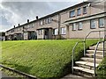
Terraced housing in Oaklands Road
Sebastopol, Pontypool.
Image: © Alan Hughes
Taken: 29 Oct 2023
0.02 miles
2
Long row of houses, Oaklands Road, Sebastopol, Pontypool
The row is nearly 50 metres long.
Image: © Jaggery
Taken: 18 Apr 2013
0.02 miles
3
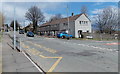
South Avenue, Sebastopol, Pontypool
South Avenue heads north away from Oaklands Road.
Image: © Jaggery
Taken: 18 Apr 2013
0.05 miles
4
South Avenue houses, Sebastopol, Pontypool
The houses are on the west side of South Avenue, between Oaklands Road and Beech Road.
Image: © Jaggery
Taken: 18 Apr 2013
0.05 miles
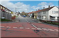
5
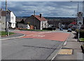
20mph zone, Oaklands Road, Sebastopol, Pontypool
The 30mph speed limit along Oaklands Road reduces to 20mph at the South Avenue junction.
A school is nearby.
Image: © Jaggery
Taken: 18 Apr 2013
0.05 miles
6
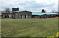
West side of Kemys Fawr Infants and Nursery School, Sebastopol, Pontypool
Viewed from South Avenue. http://www.geograph.org.uk/photo/3417188 to a view of the opposite side.
Image: © Jaggery
Taken: 18 Apr 2013
0.05 miles
7
Corner of Elm Grove and Oaklands Road, Sebastopol, Pontypool
Viewed looking north towards the southern end of The Avenue.
Image: © Jaggery
Taken: 18 Apr 2013
0.06 miles
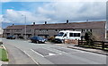
8
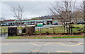
East side of Kemys Fawr Infants and Nursery School, Sebastopol, Pontypool
Viewed across The Avenue. http://www.geograph.org.uk/photo/3417544 to a view of the west side.
Image: © Jaggery
Taken: 18 Apr 2013
0.07 miles
9
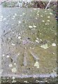
Ordnance Survey Rivet
This OS rivet can be found on the south parapet of the canal bridge. It marks a point 115.358m above mean sea level.
Image: © Adrian Dust
Taken: 16 Feb 2021
0.07 miles
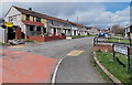
10
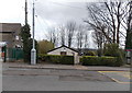
Sebastopol Labour & Community Hall, Pontypool
Set below the level of the roadway on the east side of The Avenue, between a phonebox
and a row of shops. Access is via a flight of steps through the gap in the hedge.
Image: © Jaggery
Taken: 18 Apr 2013
0.07 miles