1
Gateway at start of private road to Uplands Farm
The road starts from Oaklands Road on the edge of a housing estate.
Image: © M J Roscoe
Taken: 22 Jul 2022
0.03 miles
2
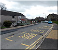
Bilingual bus stop, Oaklands Road, Pontypool
The yellow letters painted on the road show BUS STOP in English and SAFLE BWS in Welsh.
Image: © Jaggery
Taken: 18 Apr 2013
0.03 miles
3
Beech Road, Sebastopol, Pontypool
Houses on the south side of Beech Road viewed from the corner of Wellfield Lane.
Image: © Jaggery
Taken: 18 Apr 2013
0.06 miles
4
Maple Road South, Griffithstown, Pontypool
Maple Road South heads NNE away from Oaklands Road.
Image: © Jaggery
Taken: 18 Apr 2013
0.06 miles
5
Ordnance Survey Cut Mark
This OS cut mark can be found on No71 Oaklands Road. It marks a point 142.482m above mean sea level.
Image: © Adrian Dust
Taken: 16 Feb 2021
0.06 miles
6
Public footpath from Oaklands Road, Pontypool to Bevans Lane
Below the Public Footpath sign, a name sign shows Bevans Lane, though maps show the nearest point of Bevans Lane about 150 metres to the SE.
Image: © Jaggery
Taken: 18 Apr 2013
0.07 miles
7
Field near Uplands Farm, Sebastopol
Field next to private road to Uplands Farm (Balan Sports).
Image: © M J Roscoe
Taken: 22 Jul 2022
0.08 miles
8
Southern end of Springfield Road, Pontypool
Springfield Road climbs away from Sycamore Road South.
Image: © Jaggery
Taken: 18 Apr 2013
0.09 miles
9
Southern end of Sycamore Road South, Griffithstown, Pontypool
A view NNE from the corner of Springfield Road.
Image: © Jaggery
Taken: 18 Apr 2013
0.11 miles
10
Oaklands Road climbs away from the South Avenue junction, Sebastopol, Pontypool
The change from grey to red road surface highlights the start of a 20mph maximum speed zone. http://www.geograph.org.uk/photo/3417109
Image: © Jaggery
Taken: 18 Apr 2013
0.11 miles


