IMAGES TAKEN NEAR TO
Springfield Road, PONTYPOOL, NP4 5BX
Introduction
This page details the photographs taken nearby to Springfield Road, NP4 5BX by members of the Geograph project.
The Geograph project started in 2005 with the aim of publishing, organising and preserving representative images for every square kilometre of Great Britain, Ireland and the Isle of Man.

There are currently over 7.5m images from over14,400 individuals and you can help contribute to the project by visiting https://www.geograph.org.uk
Image Map
Images are licensed for reuse under creativecommons.org/licenses/by-sa/2.0
Notes
- Clicking on the map will re-center to the selected point.
- The higher the marker number, the further away the image location is from the centre of the postcode.
Image Listing (42 Images Found)
Images are licensed for reuse under creativecommons.org/licenses/by-sa/2.0
Image
Details
Distance
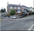
1
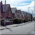
Sycamore Road South, Griffithstown, Pontypool
Viewed from the West Avenue end.
Image: © Jaggery
Taken: 18 Apr 2013
0.04 miles
2
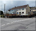
Corner of West Avenue and Sycamore Road South, Griffithstown, Pontypool
Image: © Jaggery
Taken: 18 Apr 2013
0.08 miles
3
Ashgrove Close, Griffithstown, Pontypool
Viewed from the corner of West Avenue.
Image: © Jaggery
Taken: 18 Apr 2013
0.08 miles
4
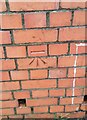
Ordnance Survey Cut Mark
This OS cut mark can be found on the wall of No68 Maple Road South. It marks a point 146.581m above mean sea level.
Image: © Adrian Dust
Taken: 16 Feb 2021
0.10 miles
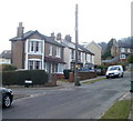
5
Corner of Maple Crescent and West Avenue, Griffithstown, Pontypool
A detached house dominates the corner of Maple Crescent, viewed across West Avenue. The large street name sign is bilingual (Welsh and English). The English text shows Maple Crescent leading to Maple Road South.
Image: © Jaggery
Taken: 21 Jan 2011
0.11 miles
6
Corner of West Avenue and South Avenue, Griffithstown, Pontypool
West Avenue houses viewed from opposite the turning into South Avenue. http://www.geograph.org.uk/photo/2240411
Image: © Jaggery
Taken: 21 Jan 2011
0.11 miles
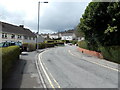
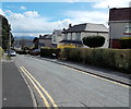
7
Southern end of Sycamore Road South, Griffithstown, Pontypool
A view NNE from the corner of Springfield Road.
Image: © Jaggery
Taken: 18 Apr 2013
0.11 miles
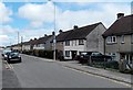
8
Maple Road, Griffithstown, Pontypool
Houses on the west side of Maple Road, viewed from near the corner of West Avenue.
Image: © Jaggery
Taken: 21 Jan 2011
0.11 miles
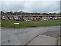
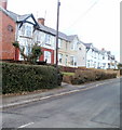
9
Zigzag roof pattern, Sycamore Road, Griffithstown, Pontypool
The houses are on the east side of the road.
Image: © Jaggery
Taken: 18 Apr 2013
0.11 miles
10
West Avenue, Griffithstown, Pontypool
A view eastwards from the junction of Sycamore Road and Sycamore Road South.
Image: © Jaggery
Taken: 18 Apr 2013
0.13 miles