IMAGES TAKEN NEAR TO
Greenhill Road, PONTYPOOL, NP4 5BQ
Introduction
This page details the photographs taken nearby to Greenhill Road, NP4 5BQ by members of the Geograph project.
The Geograph project started in 2005 with the aim of publishing, organising and preserving representative images for every square kilometre of Great Britain, Ireland and the Isle of Man.

There are currently over 7.5m images from over14,400 individuals and you can help contribute to the project by visiting https://www.geograph.org.uk
Image Map
Images are licensed for reuse under creativecommons.org/licenses/by-sa/2.0
Notes
- Clicking on the map will re-center to the selected point.
- The higher the marker number, the further away the image location is from the centre of the postcode.
Image Listing (162 Images Found)
Images are licensed for reuse under creativecommons.org/licenses/by-sa/2.0
Image
Details
Distance
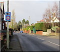
1
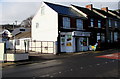
Loco in Sebastopol, Pontypool
Convenience store & off licence on the corner of Greenhill Road and Alexandra Road.
Image: © Jaggery
Taken: 24 Jan 2015
0.00 miles
2
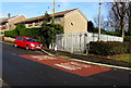
Greenhill Road electricity substation, Sebastopol, Pontypool
The identifier on the grey metal fence enclosing the Western Power Distribution electricity substation is
GREENHILL RD. SEBASTOPOL S/S No. 531481.
Image: © Jaggery
Taken: 24 Jan 2015
0.01 miles
3
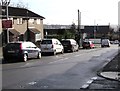
New zebra crossing 130 yards ahead, Greenhill Road, Sebastopol, Pontypool
Viewed from the corner of Rowan Crescent in late January 2015.
The same sign on the left can be seen in a Google Earth Street View taken in June 2011.
How long does a sign telling drivers about a new feature need to remain?
Image: © Jaggery
Taken: 24 Jan 2015
0.02 miles
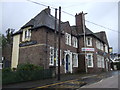
4
Page's Fish & Chips shop in Sebastopol, Pontypool
Viewed in January 2015. There has been a subtle change of name on the shop
at 126 Greenhill Road from Page's Fish Bar, seen here http://www.geograph.org.uk/photo/1577128 in October 2009.
Image: © Jaggery
Taken: 24 Jan 2015
0.03 miles
5
Speed camera sign, Greenhill Road, Sebastopol, Pontypool
The left turn ahead is for East Avenue.
Image: © Jaggery
Taken: 24 Jan 2015
0.04 miles
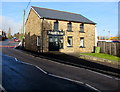
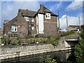
6
Canal side of the Crown, Sebastopol, Pontypool
Pub viewed across the Monmouthshire & Brecon canal. Crown Bridge (canal bridge 48) http://www.geograph.org.uk/photo/4321942 is on the right.
Image: © Jaggery
Taken: 24 Jan 2015
0.04 miles
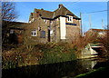
8
Crown Inn, Sebastopol
Alongside the Monmouthshire and Brecon canal.
Image: © Alan Hughes
Taken: 29 Oct 2023
0.04 miles
9
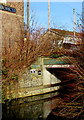
West side of Crown Bridge, Sebastopol, Pontypool
Numbered 48, Crown Bridge carries South Street over the Monmouthshire & Brecon canal.
The bridge was rebuilt in 1994. Headroom shown is 2 metres (6' 6").
http://www.geograph.org.uk/photo/1577134 to a view of the other side of the bridge.
Image: © Jaggery
Taken: 24 Jan 2015
0.05 miles
10
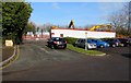
Kier demolition site, Greenhill Road, Sebastopol, Pontypool
Viewed in late January 2015. I didn't see any name sign here to show what is being demolished.
Maps show Crown Bridge Special School on the site.
Image: © Jaggery
Taken: 24 Jan 2015
0.05 miles