IMAGES TAKEN NEAR TO
Beech Road, PONTYPOOL, NP4 5BP
Introduction
This page details the photographs taken nearby to Beech Road, NP4 5BP by members of the Geograph project.
The Geograph project started in 2005 with the aim of publishing, organising and preserving representative images for every square kilometre of Great Britain, Ireland and the Isle of Man.

There are currently over 7.5m images from over14,400 individuals and you can help contribute to the project by visiting https://www.geograph.org.uk
Image Map
Images are licensed for reuse under creativecommons.org/licenses/by-sa/2.0
Notes
- Clicking on the map will re-center to the selected point.
- The higher the marker number, the further away the image location is from the centre of the postcode.
Image Listing (62 Images Found)
Images are licensed for reuse under creativecommons.org/licenses/by-sa/2.0
Image
Details
Distance
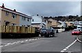
1
Wellfield Lane flats, Sebastopol, Pontypool
Viewed from the Hawthorn Road end looking towards Beech Road.
Image: © Jaggery
Taken: 18 Apr 2013
0.03 miles
2
Hawthorn Road houses, Sebastopol, Pontypool
These houses are SW of the Wellfield Lane junction on the left.
At the right edge of the view is the entrance to Lighthouse Church. http://www.geograph.org.uk/photo/3417532
Image: © Jaggery
Taken: 18 Apr 2013
0.04 miles
3
Wellfield Lane, Sebastopol, Pontypool
Wellfield Lane heads north away from Oaklands Road.
Image: © Jaggery
Taken: 18 Apr 2013
0.04 miles
4
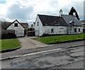
Grade II listed Ty William Ambrose Farmhouse, Sebastopol, Pontypool
Located on the corner of Beech Road and Wellfield Lane, now surrounded by modern housing.
Also known as Hanbury Farmhouse, perhaps dating from the 17th century.
Grade II listed in November 2002.
Image: © Jaggery
Taken: 18 Apr 2013
0.04 miles
5
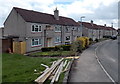
Beech Road, Sebastopol, Pontypool
Houses on the south side of Beech Road viewed from the corner of Wellfield Lane.
Image: © Jaggery
Taken: 18 Apr 2013
0.06 miles
6
Maple Road South, Griffithstown, Pontypool
Maple Road South heads NNE away from Oaklands Road.
Image: © Jaggery
Taken: 18 Apr 2013
0.07 miles
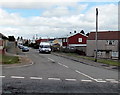
7
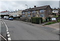
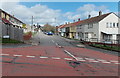
Oaklands Road climbs away from the South Avenue junction, Sebastopol, Pontypool
The change from grey to red road surface highlights the start of a 20mph maximum speed zone. http://www.geograph.org.uk/photo/3417109
Image: © Jaggery
Taken: 18 Apr 2013
0.07 miles
8
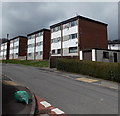
Hawthorn Road flats, Sebastopol, Pontypool
The cuboidal flats are on the north side of Hawthorn Road between South Avenue and Wellfield Lane.
Image: © Jaggery
Taken: 18 Apr 2013
0.07 miles
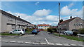
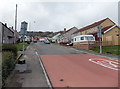
9
South Avenue, Sebastopol, Pontypool
South Avenue heads north away from Oaklands Road.
Image: © Jaggery
Taken: 18 Apr 2013
0.07 miles
10
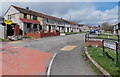
South Avenue houses, Sebastopol, Pontypool
The houses are on the west side of South Avenue, between Oaklands Road and Beech Road.
Image: © Jaggery
Taken: 18 Apr 2013
0.07 miles