IMAGES TAKEN NEAR TO
Maple Road, PONTYPOOL, NP4 5AT
Introduction
This page details the photographs taken nearby to Maple Road, NP4 5AT by members of the Geograph project.
The Geograph project started in 2005 with the aim of publishing, organising and preserving representative images for every square kilometre of Great Britain, Ireland and the Isle of Man.

There are currently over 7.5m images from over14,400 individuals and you can help contribute to the project by visiting https://www.geograph.org.uk
Image Map
Images are licensed for reuse under creativecommons.org/licenses/by-sa/2.0
Notes
- Clicking on the map will re-center to the selected point.
- The higher the marker number, the further away the image location is from the centre of the postcode.
Image Listing (68 Images Found)
Images are licensed for reuse under creativecommons.org/licenses/by-sa/2.0
Image
Details
Distance
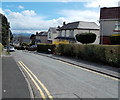
1
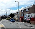
Maple Road, Griffithstown, Pontypool
Viewed from the Cwrdy Road end looking south towards the Sycamore Road junction.
Image: © Jaggery
Taken: 18 Apr 2013
0.03 miles
2
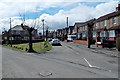
Junction of Sycamore Road and Maple Road, Griffithstown, Pontypool
Viewed from Maple Road looking towards Sycamore Road on the right.
Image: © Jaggery
Taken: 18 Apr 2013
0.03 miles
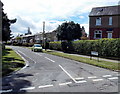
3

Sycamore Road, Griffithstown, Pontypool
A view SSW along Sycamore Road from near the Maple Road junction. http://www.geograph.org.uk/photo/3416824
Image: © Jaggery
Taken: 18 Apr 2013
0.05 miles
4
Rowan Crescent, Griffithstown, Pontypool
Rowan Crescent heads south away from Cwrdy Road.
Image: © Jaggery
Taken: 18 Apr 2013
0.05 miles
5
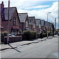
Zigzag roof pattern, Sycamore Road, Griffithstown, Pontypool
The houses are on the east side of the road.
Image: © Jaggery
Taken: 18 Apr 2013
0.07 miles
6
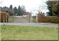
Southern entrance to Panteg Park, Sebastopol, Pontypool
The entrance is on the northern side of The Ellipse. http://www.geograph.org.uk/photo/2240397
The park has a roughly triangular shape. Its perimeters are along Rowan Crescent (west), Cwrdy Road (north) and The Avenue (east).
Image: © Jaggery
Taken: 21 Jan 2011
0.08 miles
7
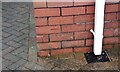
Ordnance Survey Cut Mark
This OS cut mark can be found on No28 Cwrdy Road. It marks a point 157.466m above mean sea level.
Image: © Adrian Dust
Taken: 16 Feb 2021
0.09 miles
8
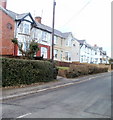
Maple Road, Griffithstown, Pontypool
Houses on the west side of Maple Road, viewed from near the corner of West Avenue.
Image: © Jaggery
Taken: 21 Jan 2011
0.09 miles
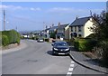
10
West Avenue, Griffithstown, Pontypool
A view eastwards from the junction of Sycamore Road and Sycamore Road South.
Image: © Jaggery
Taken: 18 Apr 2013
0.09 miles