IMAGES TAKEN NEAR TO
The Ellipse, PONTYPOOL, NP4 5AD
Introduction
This page details the photographs taken nearby to The Ellipse, NP4 5AD by members of the Geograph project.
The Geograph project started in 2005 with the aim of publishing, organising and preserving representative images for every square kilometre of Great Britain, Ireland and the Isle of Man.

There are currently over 7.5m images from over14,400 individuals and you can help contribute to the project by visiting https://www.geograph.org.uk
Image Map
Images are licensed for reuse under creativecommons.org/licenses/by-sa/2.0
Notes
- Clicking on the map will re-center to the selected point.
- The higher the marker number, the further away the image location is from the centre of the postcode.
Image Listing (104 Images Found)
Images are licensed for reuse under creativecommons.org/licenses/by-sa/2.0
Image
Details
Distance
1
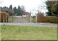
Southern entrance to Panteg Park, Sebastopol, Pontypool
The entrance is on the northern side of The Ellipse. http://www.geograph.org.uk/photo/2240397
The park has a roughly triangular shape. Its perimeters are along Rowan Crescent (west), Cwrdy Road (north) and The Avenue (east).
Image: © Jaggery
Taken: 21 Jan 2011
0.04 miles
2
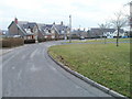
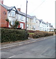
The Ellipse, Griffithstown, Pontypool
The Ellipse is an elliptically-shaped residential road surrounding the crossroads of The Avenue, West Avenue, East Avenue and Rowan Crescent. These houses are on the SE side of The Ellipse, between East Avenue and Rowan Crescent.
Image: © Jaggery
Taken: 21 Jan 2011
0.05 miles
3
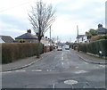
South Avenue, Griffithstown, Pontypool
Accurately named, South Avenue heads away due south from West Avenue, also accurately named.
Image: © Jaggery
Taken: 21 Jan 2011
0.05 miles
4
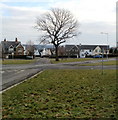
Tree inside The Ellipse, Griffithstown, Pontypool
The Ellipse is an elliptically-shaped residential road surrounding the crossroads of The Avenue, West Avenue, East Avenue and Rowan Crescent.
Image: © Jaggery
Taken: 21 Jan 2011
0.05 miles
5
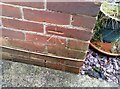
Ordnance Survey Cut Mark
This OS cut mark can be found on No3 Maple Crescent. It marks a point 144.030m above mean sea level.
Image: © Adrian Dust
Taken: 16 Feb 2021
0.07 miles
6
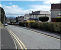
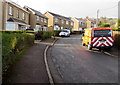
West Avenue, Griffithstown, Pontypool
A view eastwards from the junction of Sycamore Road and Sycamore Road South.
Image: © Jaggery
Taken: 18 Apr 2013
0.08 miles
7
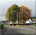
Two trees at junction of two tree roads, Sebastopol
This was an irresistible photo opportunity. Two trees, in different stages of autumn coloration, at the junction of two roads named after trees - Hawthorn Road on the left and Rowan Crescent on the right.
Image: © Jaggery
Taken: 21 Oct 2009
0.10 miles
8
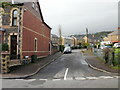
East Avenue, Sebastopol. Pontypool
Viewed from Greenhill Road. The edge of the Widdershins Centre http://www.geograph.org.uk/photo/1577157 is on the right.
Image: © Jaggery
Taken: 21 Oct 2009
0.10 miles
9
Maple Road, Griffithstown, Pontypool
Houses on the west side of Maple Road, viewed from near the corner of West Avenue.
Image: © Jaggery
Taken: 21 Jan 2011
0.10 miles
10
RAC van in East Avenue, Sebastopol, Pontypool
Text on the van's rear window shows "Thousand of quality used cars for sale" and gives a website address.
Image: © Jaggery
Taken: 24 Jan 2015
0.10 miles