IMAGES TAKEN NEAR TO
PONTYPOOL, NP4 4SA
Introduction
This page details the photographs taken nearby to NP4 4SA by members of the Geograph project.
The Geograph project started in 2005 with the aim of publishing, organising and preserving representative images for every square kilometre of Great Britain, Ireland and the Isle of Man.

There are currently over 7.5m images from over14,400 individuals and you can help contribute to the project by visiting https://www.geograph.org.uk
Image Map
Images are licensed for reuse under creativecommons.org/licenses/by-sa/2.0
Notes
- Clicking on the map will re-center to the selected point.
- The higher the marker number, the further away the image location is from the centre of the postcode.
Image Listing (661 Images Found)
Images are licensed for reuse under creativecommons.org/licenses/by-sa/2.0
Image
Details
Distance
1
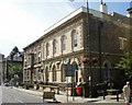
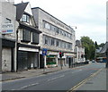
Lloyds TSB, Hanbury Road, Pontypool
Maps I've consulted don't agree on where Hanbury Road ends and Commercial Street begins, and none of them appear to record the true situation. The local AZ street atlas, online Ordnance Survey map and Streetmap all put these bank premises in Commercial Street, yet the bank's address (and that of the premises directly opposite) is Hanbury Road.
Image: © Jaggery
Taken: 23 Jun 2010
0.02 miles
2
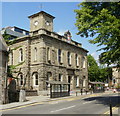
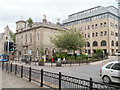
Pontypool Town Hall
Built in 1856 in the Italian Renaissance style, financed by Capel Hanbury Leigh to celebrate the birth of his son.
Image: © Jaggery
Taken: 23 Jun 2010
0.02 miles
3
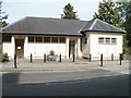
Semi-convenient public conveniences, Pontypool
There are two entrances to this Commercial Street building. The one on the right, for LADIES is open. The one on the left for GENTLEMEN is padlocked shut. A sign on the gate shows "temporarily shut".
It was 'temporarily' shut a week ago...
Image: © Jaggery
Taken: 25 May 2011
0.02 miles
4
Glantorfaen House, Pontypool
Also spelt Glantorvaen, viewed across Glantorvaen Road. The building, currently the premises of Watkins & Gunn, solicitors, was Grade II listed in 1997.
Image: © Jaggery
Taken: 27 May 2011
0.02 miles
5
Pearl Assurance House, Pontypool
The building in central Pontypool, facing Glantorvaen Road, has seen better days.
Its tatty appearance, and the number of derelict properties (such as the two on the left) give much of central Pontypool a rundown appearance.
Image: © Jaggery
Taken: 9 Jun 2011
0.02 miles
6
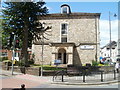
Pontypool Civic Centre
The civic centre is the main offices of Torfaen County Borough Council. The older part of the civic centre, with a clock tower, is on the corner of Hanbury Road and Glantorvaen Road. The newer extension behind it is on Glantorvaen Road. There are also council offices in County Hall, Cwmbran, but these are scheduled to close in March 2012, with staff relocating here and to other offices nearby.
Image: © Jaggery
Taken: 30 Jun 2011
0.02 miles
7
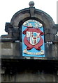
Coat of Arms on Pontypool Town Hall
Located at the top of the building http://www.geograph.org.uk/photo/1930025
The Latin inscription ET BELLO ET PACE may be translated as 'both through war and in peace' with the lower PACE showing that 'in peace' is the preference.
Image: © Jaggery
Taken: 6 Sep 2011
0.02 miles
8
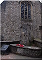
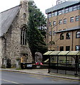
Civil defences War Memorial, Pontypool
Located alongside Hanbury Road, opposite these http://www.geograph.org.uk/photo/3328817 War Memorial gates.
There are two wreaths of poppies in front on the Memorial Stone.
On the stone, a plaque http://www.geograph.org.uk/photo/3328843 shows that the memorial acknowledges
and commemorates the contribution made by the civil defence forces
during World War II, which contributed greatly to the war effort.
The broken window panes are part of this http://www.geograph.org.uk/photo/2484256 derelict former church.
Image: © Jaggery
Taken: 11 Feb 2013
0.02 miles
9
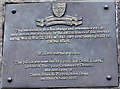
Civil defences War Memorial plaque, Pontypool
The plaque is on this http://www.geograph.org.uk/photo/3328835 War Memorial in Pontypool town centre.
Image: © Jaggery
Taken: 11 Feb 2013
0.02 miles
10
Civil Defences War Memorial, Pontypool
Viewed across Hanbury Road. http://www.geograph.org.uk/photo/3328835 to a closer view and some details.
Image: © Jaggery
Taken: 5 Dec 2016
0.02 miles