1
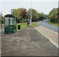
Bus stop, B4236, Llanfrechfa
The bus stop is used by the Newport Bus Monday-Saturday hourly service (route 29) from Newport to Cwmbran via Ponthir.
Ahead, just out of view, is the A4042 (Cwmbran Drive) roundabout ; on the left is the turning for Twm Barlwm View http://www.geograph.org.uk/photo/1633400 and Selby Close. http://www.geograph.org.uk/photo/1633413
Image: © Jaggery
Taken: 15 Oct 2009
0.01 miles
2
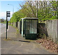
View from the bus stop opposite the hospital, near Llanfrechfa
Image: © Ruth Sharville
Taken: 28 Jan 2011
0.03 miles
3
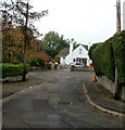
Twm Barlwm View, Llanfrechfa
Modern housing development on the eastern edge of Cwmbran.
Image: © Jaggery
Taken: 15 Oct 2009
0.06 miles
4
Turnpike Road bus stop and shelter, Llanyravon, Cwmbran
On the west side of the A4042 Turnpike Road, near a path to Liswerry Drive.
Route number 30 is shown on the bus stop pole, but that does not guarantee
that buses still use this route in April 2017. No timetables are on display here.
Image: © Jaggery
Taken: 12 Apr 2017
0.07 miles
5
Selby Close, Llanfrechfa
A short cul-de-sac adjacent to Twm Barlwm View and the B4236.
Image: © Jaggery
Taken: 15 Oct 2009
0.07 miles
6
Directions sign on the approach to Turnpike Roundabout, Cwmbran
Facing northbound traffic on the A4042 Turnpike Road.
Turnpike Roundabout is Cylchfan Dyrpeg in Welsh.
The path on the left leads to Hawarden Green and Liswerry Drive.
Image: © Jaggery
Taken: 12 Apr 2017
0.07 miles
7
Turnpike Road, Llanyravon, Cwmbran
The A4042 Turnpike Road viewed from this http://www.geograph.org.uk/photo/5348464 bus stop.
The name is doubly historical - no tolls have been payable on Turnpike Road for many decades,
and what is now a dual carriageway road would have looked very different in the era when tolls were levied.
Image: © Jaggery
Taken: 12 Apr 2017
0.07 miles
8
Stowe Path, Cwmbran
Stowe Path is a short cul-de-sac on the east side of Liswerry Drive.
Image: © Jaggery
Taken: 22 Aug 2012
0.07 miles
9
Field entrance, Llanfrechfa
The entrance to a field http://www.geograph.org.uk/photo/1534456 close to the Llanfrechfa / Croesyceiliog border. Just behind the photographer is the B4236 near the A4042 roundabout. The stile to the right of the gate appears to have had a fourth piece of horizontal wood added (note its lighter colour) which made it difficult even for this six-footer to negotiate. The unwritten message seemed to be that you may enter this field, but we won't make it easy for you. The actual message , on the post between the gate and the stile, was a request to keep your dog on a lead when near livestock.
Image: © Jaggery
Taken: 8 Oct 2009
0.08 miles
10
Field, Llanfrechfa
Looking across a field close to the Llanfrechfa / Croesyceiliog border. Just behind the photographer is the B4236 near the A4042 roundabout.
Image: © Jaggery
Taken: 8 Oct 2009
0.08 miles


