IMAGES TAKEN NEAR TO
Twm Barlwm View, CWMBRAN, NP44 8TS
Introduction
This page details the photographs taken nearby to Twm Barlwm View, NP44 8TS by members of the Geograph project.
The Geograph project started in 2005 with the aim of publishing, organising and preserving representative images for every square kilometre of Great Britain, Ireland and the Isle of Man.

There are currently over 7.5m images from over14,400 individuals and you can help contribute to the project by visiting https://www.geograph.org.uk
Image Map
Images are licensed for reuse under creativecommons.org/licenses/by-sa/2.0
Notes
- Clicking on the map will re-center to the selected point.
- The higher the marker number, the further away the image location is from the centre of the postcode.
Image Listing (124 Images Found)
Images are licensed for reuse under creativecommons.org/licenses/by-sa/2.0
Image
Details
Distance
1
Field entrance, Llanfrechfa
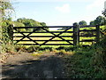
The entrance to a field http://www.geograph.org.uk/photo/1534456 close to the Llanfrechfa / Croesyceiliog border. Just behind the photographer is the B4236 near the A4042 roundabout. The stile to the right of the gate appears to have had a fourth piece of horizontal wood added (note its lighter colour) which made it difficult even for this six-footer to negotiate. The unwritten message seemed to be that you may enter this field, but we won't make it easy for you. The actual message , on the post between the gate and the stile, was a request to keep your dog on a lead when near livestock.
Image: © Jaggery
Taken: 8 Oct 2009
0.05 miles
2
Field, Llanfrechfa
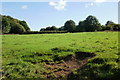
Looking across a field close to the Llanfrechfa / Croesyceiliog border. Just behind the photographer is the B4236 near the A4042 roundabout.
Image: © Jaggery
Taken: 8 Oct 2009
0.05 miles
3
A4042 towards Turnpike Roundabout, Cwmbran
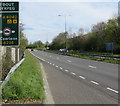
Looking to the NNE along the A4042 Turnpike Road towards the roundabout at the B4236 junction.
The edge of a directions sign http://www.geograph.org.uk/photo/5348495 is on the left.
Image: © Jaggery
Taken: 12 Apr 2017
0.05 miles
4
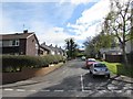
Twm Barlwm View, Llanfrechfa
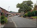
Modern housing development on the eastern edge of Cwmbran.
Image: © Jaggery
Taken: 15 Oct 2009
0.05 miles
5
Hawarden Green, Llanyravon, Cwmbran
Cul-de-sac on the east side of Liswerry Drive.
Image: © Jaggery
Taken: 12 Apr 2017
0.07 miles
6
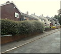
Hawarden Green, Cwmbran
Hawarden Green is a cul-de-sac on the east side of Liswerry Drive.
Image: © Jaggery
Taken: 22 Aug 2012
0.09 miles
7
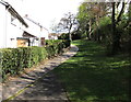
Path between Hawarden Green houses and Turnpike Road, Llanyravon, Cwmbran
The trees on the right are at the edge of the A4042 Turnpike Road.
Image: © Jaggery
Taken: 12 Apr 2017
0.09 miles
8
View from the bus stop opposite the hospital, near Llanfrechfa
Image: © Ruth Sharville
Taken: 28 Jan 2011
0.09 miles
9
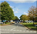
Gwent Police HQ entrance, Croesyceiliog, Cwmbran
An entrance road from Turnpike Road. It is advisable to obey the sign on the left - "Police Vehicles Only"
Image: © Jaggery
Taken: 8 Oct 2009
0.09 miles
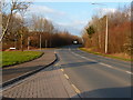
10
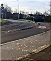
Towards a bend in Turnpike Road, Cwmbran
The 20mph speed limit on Turnpike Road increases to
the National Speed Limit on the dual carriageway road ahead.
Image: © Jaggery
Taken: 31 Mar 2024
0.10 miles