IMAGES TAKEN NEAR TO
Dorstone Walk, CWMBRAN, NP44 8TD
Introduction
This page details the photographs taken nearby to Dorstone Walk, NP44 8TD by members of the Geograph project.
The Geograph project started in 2005 with the aim of publishing, organising and preserving representative images for every square kilometre of Great Britain, Ireland and the Isle of Man.

There are currently over 7.5m images from over14,400 individuals and you can help contribute to the project by visiting https://www.geograph.org.uk
Image Map
Images are licensed for reuse under creativecommons.org/licenses/by-sa/2.0
Notes
- Clicking on the map will re-center to the selected point.
- The higher the marker number, the further away the image location is from the centre of the postcode.
Image Listing (113 Images Found)
Images are licensed for reuse under creativecommons.org/licenses/by-sa/2.0
Image
Details
Distance
1
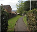
Dorstone Walk, Llanyravon, Cwmbran
Dorstone Walk descends from Llanyravon Way towards Manorbier Drive.
Image: © Jaggery
Taken: 12 Apr 2017
0.02 miles
2
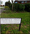
Rumney Walk/Tro Rhymni name sign Cwmbran
The English/Welsh sign faces Llanyravon Way at the western end of Rumney Walk. http://www.geograph.org.uk/photo/5397386
Image: © Jaggery
Taken: 12 Apr 2017
0.04 miles
3
Warning sign - patrol, Llanyravon Way, Cwmbran
On the descent towards Llanyrafon Primary School. The Welsh spelling Llanyrafon and the slightly Anglicised Llanyravon are both in use in this area.
Image: © Jaggery
Taken: 12 Apr 2017
0.05 miles
4
Toward a path beyond a gap in the hedge, Llanyravon, Cwmbran
Viewed across Llanyravon Way. The path http://www.geograph.org.uk/photo/5346887 is Dorstone Walk.
Image: © Jaggery
Taken: 12 Apr 2017
0.05 miles
5
Bilingual name sign facing Llanyravon Way, Llanyravon, Cwmbran
Located in a gap in a hedge here, http://www.geograph.org.uk/photo/5346896 the sign shows that Dorstone Walk is Tro Tref Y Cernyw in Welsh.
Image: © Jaggery
Taken: 12 Apr 2017
0.05 miles
6
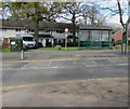
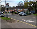
Llanyravon Way bus stop and shelter, Cwmbran
Among the buses using this stop opposite Kidwelly Road in April 2017
are Newport Bus buses on route 29B to Newport via Ponthir and Caerleon.
A telecoms cabinet is on the left.
Image: © Jaggery
Taken: 12 Apr 2017
0.05 miles
7
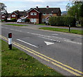
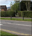
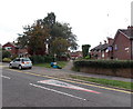
Llanyravon Way speed bumps, Llanyravon, Cwmbran
The bumps across Llanyravon Way are in a 20mph maximum speed zone near a primary school.
Image: © Jaggery
Taken: 12 Apr 2017
0.06 miles
8
Rumney Walk, Llanyrafon, Cwmbran
Rumney Walk connects Llanyrafon Way (from where the photo was taken) with Narberth Crescent.
Image: © Jaggery
Taken: 11 Feb 2010
0.06 miles
9
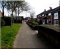
Rumney Walk, Cwmbran
Emphasising that the path ahead is a walk, there a No Cycling sign on a pole on the grass.
The sign is surrounded by boxes and bags of rubbish awaiting collection.
Painted on the road surface, an elongated triangle warns that a school is nearby.
Image: © Jaggery
Taken: 30 Aug 2013
0.07 miles
10
Rumney Walk, Llanyravon, Cwmbran
From Llanyravon Way to Narberth Crescent (ahead).
Image: © Jaggery
Taken: 12 Apr 2017
0.08 miles