IMAGES TAKEN NEAR TO
Stow Path, CWMBRAN, NP44 8SE
Introduction
This page details the photographs taken nearby to Stow Path, NP44 8SE by members of the Geograph project.
The Geograph project started in 2005 with the aim of publishing, organising and preserving representative images for every square kilometre of Great Britain, Ireland and the Isle of Man.

There are currently over 7.5m images from over14,400 individuals and you can help contribute to the project by visiting https://www.geograph.org.uk
Image Map
Images are licensed for reuse under creativecommons.org/licenses/by-sa/2.0
Notes
- Clicking on the map will re-center to the selected point.
- The higher the marker number, the further away the image location is from the centre of the postcode.
Image Listing (164 Images Found)
Images are licensed for reuse under creativecommons.org/licenses/by-sa/2.0
Image
Details
Distance
1
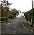
Stowe Path, Cwmbran
Stowe Path is a short cul-de-sac on the east side of Liswerry Drive.
Image: © Jaggery
Taken: 22 Aug 2012
0.01 miles
2
Selby Close, Llanfrechfa
A short cul-de-sac adjacent to Twm Barlwm View and the B4236.
Image: © Jaggery
Taken: 15 Oct 2009
0.02 miles
3
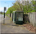
Turnpike Road bus stop and shelter, Llanyravon, Cwmbran
On the west side of the A4042 Turnpike Road, near a path to Liswerry Drive.
Route number 30 is shown on the bus stop pole, but that does not guarantee
that buses still use this route in April 2017. No timetables are on display here.
Image: © Jaggery
Taken: 12 Apr 2017
0.02 miles
4
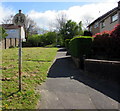
No Cycling sign facing Liswerry Drive, Llanyravon, Cwmbran
Alongside a footpath ascending towards Hawarden Green houses at the edge of the A4042 Turnpike Road.
Image: © Jaggery
Taken: 12 Apr 2017
0.02 miles
5
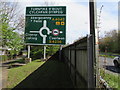
Directions sign on the approach to Turnpike Roundabout, Cwmbran
Facing northbound traffic on the A4042 Turnpike Road.
Turnpike Roundabout is Cylchfan Dyrpeg in Welsh.
The path on the left leads to Hawarden Green and Liswerry Drive.
Image: © Jaggery
Taken: 12 Apr 2017
0.02 miles
6
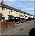
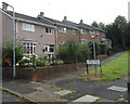
Long row of houses, Liswerry Drive, Llanyravon, Cwmbran
Viewed from the corner of Stowe Path.
Image: © Jaggery
Taken: 12 Apr 2017
0.03 miles
7
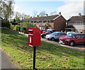
Queen Elizabeth II postbox on a Llanyravon corner, Cwmbran
On the corner of Liswerry Drive and Rhodri Place.
Image: © Jaggery
Taken: 12 Apr 2017
0.04 miles
8
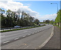
Turnpike Road, Llanyravon, Cwmbran
The A4042 Turnpike Road viewed from this http://www.geograph.org.uk/photo/5348464 bus stop.
The name is doubly historical - no tolls have been payable on Turnpike Road for many decades,
and what is now a dual carriageway road would have looked very different in the era when tolls were levied.
Image: © Jaggery
Taken: 12 Apr 2017
0.04 miles
9
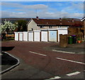
Row of eight lockup garages, Liswerry Close, Llanyravon, Cwmbran
Viewed from the corner of Liswerry Drive.
Image: © Jaggery
Taken: 12 Apr 2017
0.05 miles
10
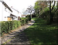
Path between Hawarden Green houses and Turnpike Road, Llanyravon, Cwmbran
The trees on the right are at the edge of the A4042 Turnpike Road.
Image: © Jaggery
Taken: 12 Apr 2017
0.06 miles